A long time ago, over half a billion years ago, the solid rocks of Southern Ontario, south of the shield, did not exist. The Precambrian rocks of the Laurentian Shield had been present for aeons, but bedrock of we now know as the settled area of this province was deposited in a tropical ocean during the Palaeozoic Era, roughly from half a billion years to one third of a billion years ago. Toronto’s bedrock called the Georgian Bay Formation, which is seen at the bottom of the Brickworks north quarry wall, is close to 450,000,000 years old. It is likely that somewhat younger rocks were deposited above, but have since been eroded away.
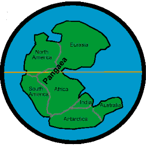
Map of Pangaea The World 225 Million Years Ago, in the Triassic
by about 200,000,000 years ago most of this worlds continents had come together to form the great continent of Pangaea. In this process North America bumped into Africa and a range of mountains were pushed up that we now call the Appalachians. Since then, North America continued its drift north and the Atlantic Ocean opened up. It is thought that in early and mid Tertiary times this part of North America drained to a much enlarged Gulf of Mexico. By the late Tertiary, the St Lawrence rift system had opened up and the Great Lakes Basin drained to the Atlantic. Before the Ice Age there were no great lakes, only shallow basins, except for Lake Superior which had originated aeons earlier as a rift valley lake in the Central North American Rift System.
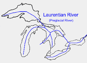
Map of Laurentian River
The river that drained this area, the Laurentian River, flowed through the Toronto area. It had started from Lake Superior and flowed though the Lake Huron Basin, the Georgian Bay Basin and, through a valley in bedrock, now hidden by the Oak Ridges Moraine, to the Lake Ontario Basin and thence by the St. Lawrence Valley to the Ocean. Soundings of the bedrock disclosed low stretches through this valley suggesting that the Laurentian River at times took a Humber Route and at times a Don Route through our area. While the Laurentian River has been blocked by the Oak Ridges Moraine, the porous nature of this land form allows some water to flow through. Recently, drilling in High Park discovered this aquifer and water from the Laurentian River came up to flow once again on the surface.
Other Pages in this Series
- Don Valley Brick Works Quarry - North Wall
- How The Glaciers Started
- The Great Delta
- Maximum Extent of the Ice Sheets
- The Story From The Lakes
- The Story of the Trees
- Early Stages of the Retreat of the Ice Front
- Drumlins and Flutings
- Lake Iroquois & its shore cliff
- The Wide Valley of the Lower Don
- Geology References