The deep wide lower Don valley, so noticeable from the Prince Edward (Bloor Street) Viaduct and The Leaside Viaduct, was formed after the draining of Lake Iroquois, when the nearest ice front was somewhere around North Bay. At that time the level of water in the Lake Ontario basin fell to (or near) sea level. As a result of this and the lack of stabilizing vegetation, many streams, including The Don, cut deep ravines through the soft alluvial plain of sand, gravel and clay tills to this lower lake called Admiralty Lake. Some geologist believe there were two lakes they refer to as the Admiralty Lakes.
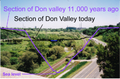
On the above photo of the Don Valley, taken from the Prince Edward Viaduct, I have drawn two valley profiles; both free hand. The first, in black, is a section of the present valley.
The second in purple is my guess of the valley 11,000 years ago. I assumed that there has been some erosion of the shoulders of the valley over the last eleven millennia and that the early ravine slopes were quite steep, possibly 45 degrees. Nothing in the resulting sketch should be considered accurate. It is intended only to give some idea of the size of that postglacial valley.
Another factor is simply the time involved. Hurricane Hazel is called the 100 year storm, so there have been over 100 Hurricane Hazels and countless lesser, but still destructive storms, since the Don started to flow across the land that had been covered by Lake Iroquois. The power of water over time is immense.
The crustal block that underlies most of The Province of Quebec and north- eastern Ontario,together with the eastern end of Lake Ontario and the St. Lawrence valley had been under as much as 2 km of ice for over 100,000 years and thus had been pushed hundreds on metres down into the mantle. The western end of the lake was freed from the ice several thousand years earlier than the easern end, and probably had only been under the ice sheet for a small part of the Wisconsinan ice age. As a result it rebounded first, tilting that end of the Lake Ontario basin up at the time of Lake Iroquois (and for some time after). The eastern end of Lake Ontario and the St. Lawrence valley, having been depressed more, have rebounded more; thus the present in level of the Lake Iroquois shoreline varies from 55 metres above sea level near the Humber to 68 metres at the east end of Scarborough.
With the retreat of the ice front north of the St. Lawrence valley, Lake Iroquois drained and the water level in the basin fell to about sea level. The Don and the other rivers and streams cut deep ravines down to meet the new low level lake. At that same time the sea came up the St. Lawrence valley as far as, and possibly into, the Lake Ontario basin covering all of Montreal.
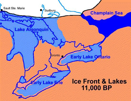
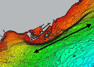
Admirealty or Early Lake Ontario cut shore cliffs or bluffs as did Lake Iroquois before and the present lake after. A bluff. which has been named the Toronto Scarp, from that early lake still exists under the water off Toronto Island. An enlarged portion of the Lake Ontario map showing this bluff is shown below.
With the weight of ice removed, this block of the earth’s crust slowly rose again to its present level. It is still rising but at an much slower rate. As the elevation of outlet to the St Lawrence increased, the level of Lake Ontario rose and water came up the ravines. Many of these water filled ravines were closed off by sand bars and became small lakes. Grenadier Pond is a good example. The lower Don Valley became filled with sediment washed down from the upper Don Watershed. The level of The Don changes little from the Prince Edward Viaduct to the lake. The older channel with a normal slope is buried beneath this sediment,
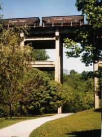
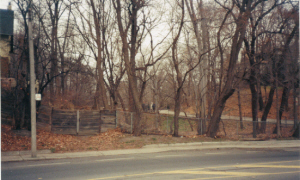
While Mashquoteh, Taddle Creeks (see picture below of the Wychwood Ravine at Davenport, which is usually considered the upper reach of Taddle Creek) and Garrison Creeks have no noticeable gullies or ravines leading away south from the Lake Iroquois shorecliff, Yellow Creek, Mud Creek and to a lesser degree, Castle Frank Brook have cut quite deeply below the level of the old lake as demonstrated in the picture below on left of the CPR bridge over Yellow Creek. The CPR track was laid along the old beach of Lake Iroquois. The depth of valley cutting is a function of the distance to the lake or the Don valley.
By 10,000 years ago most if not all the continental ice sheet had disappeared, the climate became warmer; the forest changed to one of deciduous trees dominated by White and Red Oaks with some conifers especially White Pines and Hemlocks. The Wisconsinan Ice Age was over and a new environment existed.
Other Pages in this Series
- Don Valley Brick Works Quarry - North Wall
- Before the Ice Age
- How The Glaciers Started
- The Great Delta
- Maximum Extent of the Ice Sheets
- The Story From The Lakes
- The Story of the Trees
- Early Stages of the Retreat of the Ice Front
- Drumlins and Flutings
- Lake Iroquois & its shore cliff
- Geology References