Why did so many of Toronto’s rivers and streams flow in a south-easterly direction and often parallel to each other for considerable distances?
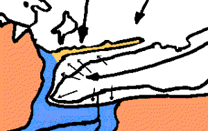
When the great Laurentide Ice Sheet made its final push forward about 13,000 years ago, and started to melt back to free our area from ice for the last time, the direction of ice flow over Toronto was from the south east to the north west. The ice lobe filling the Lake Ontario basin flowed down the basin from the north-east, except that at the end of the basin it fanned out so that in the Toronto area it was actually pushing out in a north west direction up towards the Oak Ridges Moraine. During that time, the ice continued to flow forward, but the warmer climate encouraged the ice to melt faster than the ice was flowing forward so the ice front retreated. It was probably not a steady process, but of one advance and retreat; however, for most of that time (about 1000 years) the ice front retreated.
(This map shows how the ice flow fanned out at the west end of Lake Ontario)
When ice sheets are thick (two kilometres deep over Toronto at one time) they pick up material, but when they finally melt, they drop a mixture of clay, sand, gravel and boulders that geologists call till or boulder clay. When the ice was thinning out over our area, it did both and, as it was moving towards the north west, it left grooves and ridges of till, oriented north-west/south- east. Where the ridges and grooves are small and close together they are called fluting.
Where these ridges are large (height 18-60 m. and length 400-2000 m) they are called drumlins. They have also been called sowbacks, whalebacks, or elliptical hills. How the drumlins formed is a matter of considerable conjecture. They have obviously been shaped by the ice moving over them, but how much results from material being dropped by the melting ice and how much from erosion by the moving ice, is a matter of speculation. It is believed that the ice sheet did carry an extraordinary load of material then, which contributed to the formation of the ridges. The moving ice would help to shape them. Over six thousand drumlins have been located in Southern Ontario. They are composed of medium textured till with little heavy clay or light sand. In places lenses of gravel & sand or stratified clay may be found. While the soils can be fertile, steep slopes and frequent stones make cultivation difficult.
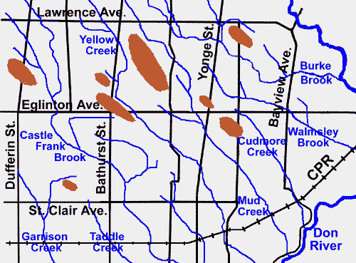
Map of Drumlins in central Toronto
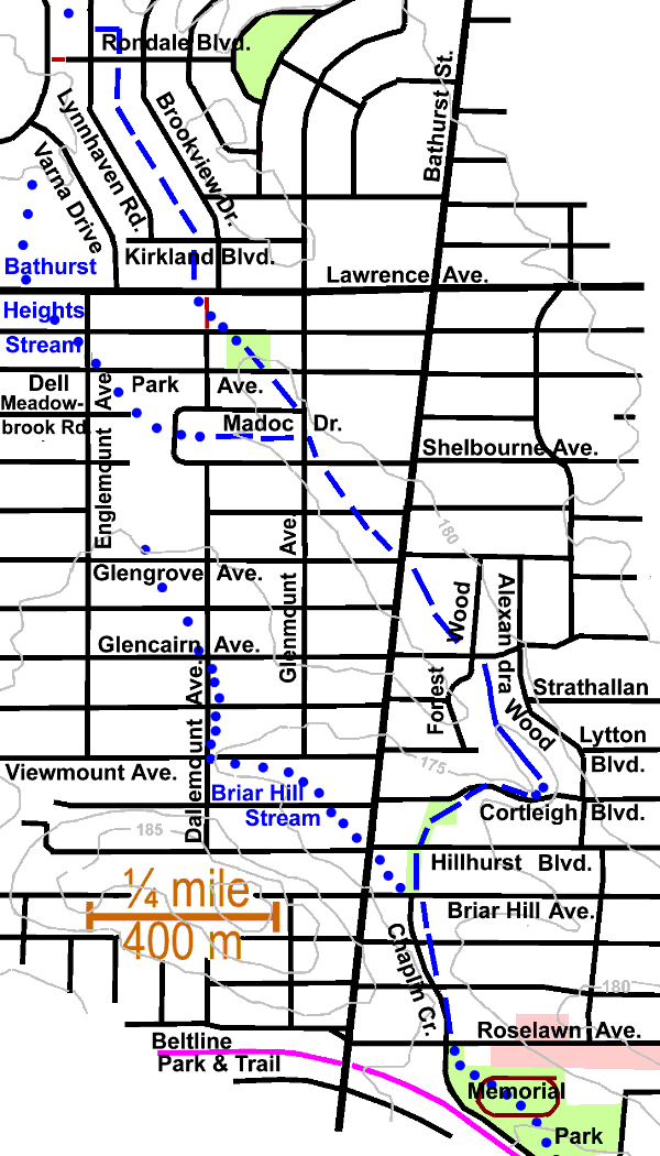
The grooves formed the valleys that the new streams flowed through over the land now free of ice. These grooves or valleys, shaped as they were under the ice would not be complete valleys for streams. In places they run for several kilometres then the steam had to find other grooves. One example is Yellow Creek which ran from the Downsview area for nearly four km almost due south- east to Cortleigh Blvd. a bit east of Bathurst, then jogged west into a short groove less than 1000 metres long, the bottom of which it filled with sediment, then jogged southerly to the groove which it later shared with the Beltline Railway. The latter groove continued for two and a half km in a direction close to S 60 E to Yonge Street and Mount Pleasant Cemetery where the direction changed again to around S30E to the Iroquois shoreline. It is noticeable that Castle Frank Brook and Mud Creek run parallel to Yellow Creek and even duplicate some of these changes in direction, This suggests that the ice was flowing in slightly different directions over this period of ice front retreat. (To see how Yellow Creek changed direction, see the Bathurst Heights Reach Map.)
Where there was a difference in elevation between grooves, small ravines were cut by the stream in its quest for hydrostatic equilibrium. An example is the small ravine cut by Yellow Creek behind the houses on the west side of Alexandra Wood. Mud Creek had well developed ravines both north-west and south-east of its Yonge Street crossing, but crossed that road in a flat swampy area. Scadding speaks of Yonge Street between Davisville and Eglinton “A tract of rough country was now reached, difficult to clear and difficult to traverse with a vehicle. Here a genuine corduroy causeway was encountered, a long series of small saw-logs laid side by side over which wheels jolted deliberately. In the wet season portions of it, being afloat, would undulate under the weight of a passing load.”
Other Pages in this Series
- Don Valley Brick Works Quarry - North Wall
- Before the Ice Age
- How The Glaciers Started
- The Great Delta
- Maximum Extent of the Ice Sheets
- The Story From The Lakes
- The Story of the Trees
- Early Stages of the Retreat of the Ice Front
- Lake Iroquois & its shore cliff
- The Wide Valley of the Lower Don
- Geology References