There is physical evidence on the ground of four major advances of the continental glaciers and from deep ocean probes of many more ice sheets,. It is not possible to know much if anything at all about the early ice advances; because later glaciers destroyed much of the evidence. Much of our geological history has not only been shaped but also been annihilated by the glaciers; however, near the edge of the ice sheets or beyond them moraines and other deposits from earlier stages have escaped and from them we can get a glimpse of what happened. Beyond the greatest extent of the Wisconsinan Ice Sheet, the last major advance, are found older moraines. Their relative age is indicated by the amount of weathering and in places their overlaps.
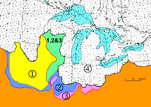
This map shows the maximum coverage around the Great Lakes of the four named advances or stages. The present Great Lakes are shown in light blue to help visualize the coverage; they were of course not present then, but filled with ice. The greatest extent of the Wisconsin Ice Sheet about 18,000 years ago is show in speckled white. The Yellow and green areas are those beyond the Wisconsinan coverage that had been covered by the Nebraskan, the oldest. The blue areas show that the second major advance the Kansan pushed a bit further south into the area shown in blue. The third, the Illinoian, pushed a bit further south but not in the west; the mauve and green areas.
The four named advances or stages are:
- Nebraskan - 800,000 (±300,000) years ago, {yellow and green}
- Kansan - 600,000 (±200,000) years ago, {blue}
- Illinoian - Possibly from 250,000 to 135,000 years ago) {mauve and green}
- Wisconsinan - prob. lasting from 100,000 to 5,000 years ago) {speckled white}
Other Pages in this Series
- Don Valley Brick Works Quarry - North Wall
- Before the Ice Age
- How The Glaciers Started
- The Great Delta
- The Story From The Lakes
- The Story of the Trees
- Early Stages of the Retreat of the Ice Front
- Drumlins and Flutings
- Lake Iroquois & its shore cliff
- The Wide Valley of the Lower Don
- Geology References