2.2 kilometres of Yellow Creek from Yonge Street to Mount Pleasant Road.
After crossing Yonge Street, Yellow Creek flowed through Mount Pleasant Cemetery into the ravine now called the Vale of Avoca, named for the valley of the Avoca River in County Wicklow, Irland, or possibly for the poem by Thomas Moore. See http://www.valeofavoca.com/. Here Yellow creek comes to the surface for a while in a well treed ravine with some older forest; (Beech Black. Cherry White Pine White & Red Oaks) and some new growth forest of exotics (Norway Maple, Crack Willow, Horse Chestnut, Manitoba Maple.). The stream goes underground again in the south end of David Balfour Park and flows under Mount Pleasant Road to join with water coming from Castle Frank Brook via the Spadina Trunk Storm Sewer east of Mount Pleasant Road. There are records of several sawmills in this reach. It lay in Former City of Toronto, part of which was earlier in the Village of Yorkville. One of the City’s Discovery Walks, “Central Ravines, Belt Line & Gardens,” follows this reach as well as the reaches above and below. Sanitary sewage flows via the Core Interceptor to the Ashbridges Bay Sewage Treatment Plant. Storm water still flows through this valley, partly in an open channel and partly in storm sewer sections.
If arriving by subway at the Davisville Station, cross Yonge Street to the east side and walk south the Beltline bridge. There are steps that can be climbed to its deck. Coming from the Beltline Reach, one has crossed the bridges over the TTC yards and Yonge Street. From the bridge one can look down on the site of one of several sawmills that operated along this reach in what are now TTC yards. Scadding also mentions a pottery, Whitmore’s Pottery Burned in 1830 and taken over by John Walmsley. An old map shows a brewery near here. Look south to see the low spot on Yonge street where Yellow Creek crossed over to Mount Pleasant Cemetery. After crossing the bridges, one can look at a map of the Beltline Park, which has recently been named after Kay Gardner, the former City councillor responsible for planning this park. Note small planted trees in this area: Cedar, Sugar Maple, Hemlock, White Pine, Elm, Red Oak, & Red Bud. After a delay of several years; The Beltline Park is being extended east; eventually to cross Mount Pleasant Cemetery east of Mount Pleasant Road in the valley of Mud Creek. Note the large White Oak which was protected during construction of the underground parking garage for the nearby Condo.
Enter Mount Pleasant Cemetery through the gate in the north wall. Point out nearby trees: large old White Oak, White Spruce, Ginkgo, Larch, Douglas Fir, Silver Maple, Austrian and Scotch Pines, Yew, European Beech, and many others. Mount Pleasant Cemetery’s tree collection is one of the finest on this continent. Pass Ginkgoes and White Elm. Note Douglas Fir. Continue along roads south along slope and into the valley. Note the stone railing of an old bridge over Yellow Creek and the low flat area which used to contain a pond. (a picture of this pond is in the sidebar on this cemetery). Continuing down the valley, which has been nearly filled to within ten metres of the top with soil from the construction of the subway. One can see Oaks, maples, basswood and Elms growing on original slopes above the filled valley bottom. There are many famous men and women buried here, but that is another story.
Click here to see sewers. Double click to remove.
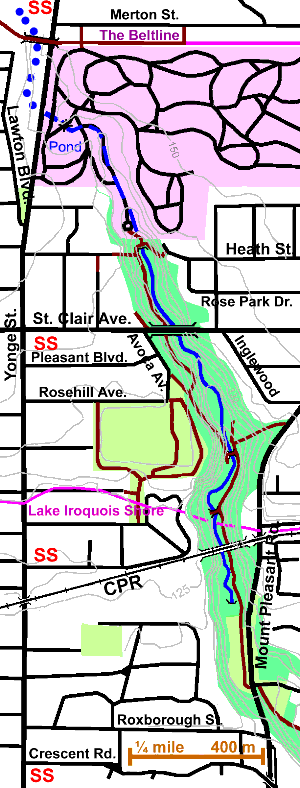
Leave the cemetery by the gate in the south fence and enter The Vale of Avoca. By the slope one walks down one can judge the depth of fill placed in the valley by the cemetery managers. The stream comes above ground here and continues on the surface until the south end of David Balfour Park. The valley can be reached here from Heath Street by stairs on both east and west sides of the ravine. Also one can climb the west stairs to vistit the Deer Park Community and its fine oaks. There are trails on both sides of the stream, but the west side is better. Note a bit of old forest (Red Oak Beech Hemlock) in the new (Norway & Silver Maples, Crack Willow, Horse Chestnut, Manitoba Maple. White Ash; Japanese Knot Weed; TouchMeNot). This is a good place to observe the structure of the forest with trees shrubs ferns herbs and vines. Note the gabion baskets used to control erosion. You will see many wet areas and springs traversed by board walks. They result from water following the sandy areas laid down in interglacial times. (For more about interglacial deposits see note on Don Valley Brickworks Park North Wall).
Before arriving at the St. Clair Viaduct, you will pass a point where an early road crossed the valley and the location of a sawmill. This is not visable now. The woodland here varies form quite good to poor. Beyond the fence on the east side we can see a bit of older native forest; (White & Red Oaks, Beech, Black Cherry, White Pine, Basswood Ash, & Hemlock). Compare this with the largely exotic new growth forest on the west side, (Norway Maple, Crack Willow, Horse Chestnut, Manitoba & Silver Maples, Mulberry & Black Locust). The two prominent native tree species in the west side stand are Manitoba & Silver Maples, which while they have a role in the forest are not normally as dominant as they are here. The vigorous presence of Norway Maple, an invasive exotic, in this and many other ravines is very troublesome. The Task Force to Bring Back the Don and the City are considering projects to remove some undesirable exotics and encourage the growth of native trees. See Summerhill Slope Restoration.
Go under St. Clair Viaduct which was built in 1924. The west side trail climbs the ravine wall to nearly the top before descending to the valley bottom. It passes through woodland dominated by Norway Maple, an invasive exotic. Armour stone and gabion baskets line the stream-bed. Look for storm water outfalls; there are several along the open part of this stream.
On the east side we find Manitoba Maple, Basswoods or Lindens, an old garden, planted Norway Spruce, Ash etc. A large chunk of cement is seen, which is possibly part of one of the old sawmill that operated along Yellow Creek. Old maps show several sawmill locations. After passing an earth work that is likely the site of a sawmill and road, go into a clearing that is closing in as it is being naturalized by cessation of mowing and an early planting by The Task Force to Bring Back the Don of White Pine, Silver Maple, & Ash. This has been augmented by seeding in of Hard & Norway Maples.
Near where the main trail (from the west side) crosses over a small bridge to the east side, we find a clump of witch hazel and a cluster of old Oaks both white and red plus Beech, Hemlock, Maples, Honey Locust, Black Locust, and Ash. High on the west wall one might glimpse Rosehill Reservoir, built in 1873. The Lake Iroquois shore cliff is not readily noticed but lies just south of this reservoir & north of the CPR railway. The railway bridge is nearly at the level of Lake Iroquois. One can see clearly here how deeply the ravine was cut by Yellow Creek in the last 10,000 years. Unstable slopes have prompted rehabilitation of the woodland on the west side. A preponderance of Norway Maples and other factors has resulted in severe erosion. The City has started to cut out undesirable trees and plant better ones.
Past CPR Bridge we come out into more open parkland. Are park lands man-made savannah? Trees here include Honey Locust, Norway Maple & Ash. Shortly the stream goes underground through “park” (mowed) with Crab Apples, Sumac, & Black Locust; Maples Ash & Elms also occur. Cross Mount Pleasant Extension (built late 1940s) (carefully - watch the traffic) to The Park Drive Reservation Reach.