1.2 kms of Taddle Creek
For some time it has been assumed that this small stream was the source of the Taddle; however, some recently uncovered evidence indicates that it may have fed a tributary of the Garrison Creek. There is also another possibility. It may have sunk into the sands and gravels of the Iroquois beach, so feeding an aquifer that provided water to both streams and possibly Russel Creek. Which ever stream it fed, it is the only portion of either where a bit of the old stream still flows above the ground. Like the upper Garrison, this is an old stream which flowed into Lake Iroquois around 12,000 BP (years ago). The lower Taddle would have only started to flow to the Don River about 11,000 BP, after Lake Iroquois was drained into the Champlain Sea. You say that Taddle Creek is not a tributary of The Don! You are correct now; however, 11,000 BP, it would have been a tributary of the Don River, as the lake had dropped to about sea level. (See The Wide Valley of the Lower Don).
That is not the only point of contention. Some believe that the Wychwood Creek started north of St Clair. I have my doubts; there may have been a drainage ditch that crossed St. Clair in settlement days, but the original stream probably did not start far from Hocken and Wychwood Avenues. There were several, largely seasonal, ponds, often called “the Poverty ponds,” in the area along Wychwood Avenue south of St. Clair.
This area is largely residential, (varying from working class to professional and middle class) with some commercial strips along Dupont, Davenport and Bathurst; and industrial along the CPR. It includes the very noteworthy Heritage District of Wychwood Park. Tree cover varies from the fine Oaks above the Iroquois Bluff to absent in the commercial industrial areas. Surface water and combined sewer overflow water flow via storm trunks to Toronto Bay near Fort York. Sanitary water is piped to the Ashbridge’s Bay Sewage Treatment Plant.
To walk this stream, start at Wychwood and St. Clair and walk down Wychwood. The stream probably started around Hocken and Wychwood where there is a noticeable low spot. Look east along Helena; the valley can be seen clearly. In April 14, 1903, The Toronto World informed its readers that “a much needed sidewalk is being put down on Helena Avenue.” To the west note the Wychwood Car Barns where street cars were sheltered and repaired from 1913 to 1978. Walk east on Alcina to the low point listen at the sewer catch basin to hear the stream still flowing.
Click here to see sewers. Double click to remove.
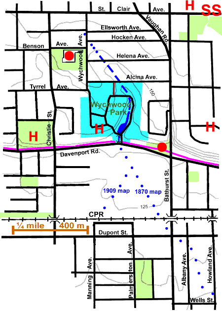
Two or three houses west of the low point find a gate to a path leading between the houses into Wychwood Park, a significant enclave; see Wychwood. Follow this path to the internal road and go east and south. The valley is a distinct ravine here and after passing the Tennis courts the stream appears above ground flowing into a pond. After passing through a culvert it flows down to Davenport Road where it disappears into the City storm sewer. The stream’s ravine has been cut into the Iroquois Shore Bluff, which stretches to the east and west, just north of Davenport Road.
In the late 1800s, there were a number of market gardens on the relatively flat land below the Iroquois Shore Bluff. Notable among the market gardeners was a Mr. MacNamara, an enterprising Irish Immigrant.
There is little or no evidence of the stream south of Davenport Road. An 1870 map shows it flowing to the south-east and would lead one to think that it connected with Taddle Creek around Albany Avenue and Wells Street. A 1909 map on the other hand shows it taking a turn to the south-west, which suggests that it joined Garrison Creek near Bloor Street, possibly its London Stream tributary. One could even conjecture that it wandered to Boor and Palmerston to feed Russell Creek.
It is suggested that you walk east along Davenport to Bathurst, viewing the Toll Keepers Cottage in the small Park at the north- west corner of Davenport and Bathurst. Walk south along Bathurst, under the CPR to Dupont. This is the main line of the CPR through Toronto, which follows the Iroquois beach for several kilometres here, At Dupont one has the choice of a Taddle connection and walking east to Albany and south to follow the Annex Reach of the Taddle, OR choosing the Garrison connection and walking west to Manning and south to London Street and the Garrison’s London Stream tributary. One could also walk west to Palmerston and then south to Bloor and Palmerston to continue on Russell Creek.