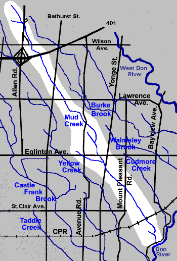
Mud Creek, also known as Mount Pleasant Brook, originally rose just east of the main Downsview Airport airstrip and flowed south-east to reach the Don River at the Don Valley Brick Works. Today, some Mud Creek water still flows in culverts, pipes. ditches and open water courses across the city, but little reaches the Don though its present mouth as storm water is diverted to and from other streams. Mud Creek, as we now know it, traverses the city, hidden under industrial lands, suburbs, offices and apartment buildings, a cemetery, and several ravines and parks. Above ground water is rarely seen, except in the Moore Park Ravine and most of that is from the Cudmore sub-watershed. It was approximately eleven and a half kilometres long and had 1.7 km in tributaries. Mud Creek drops 115 metres (275 feet) from its source at Downsview Airport to its junction with the Don River, a point which is 84 metres above sea level. The lower portion, the Moore Park Ravine, cuts deeply into glacial and interglacial deposits. Mud Creek is divided into seven reaches in this account. Downsview Reach, Lawrence Manor Reach, Coldstream Reach, Lytton Park Reach, Eglinton Park Reach, Davisville Reach and Moore Park Ravine Reach. Three small tributaries, Willow Creek, St. Clements Stream and Chorley Stream, are briefly described.