1.2 km of Mud Creek, Lawrence Avenue to Avenue Road
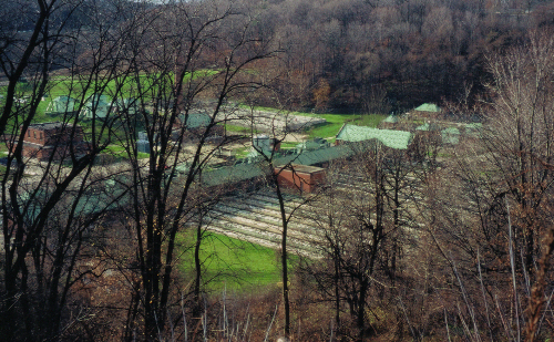
Prior to 1997, the north half of this reach was in the Township of North York which became the former City of North York. The south part was in the Township of York before being annexed to the former City of Toronto in mid twentieth centuary. Sanitary sewerage from both areas flows to the NTSTP. Storm water from the north part flows to the North Toronto Storm Trunk Sewer also known as Burke Brook). The south part drains to the Mud Creek Storm Sewer. As most of this ravine is in private hands, we must walk around it rather than through it.
From Lawrence Avenue, follow Ledbury Street south to Caribou Road and into Caribou Park. Here, the ravine is partly filled in, existing as a grassed trough up to two metres deep. This is the beginning of the Coldstream Ravine, which has a bit of a mixed history and drainage. As Caribou Park includes a playground and lawn, tree cover is moderate and dominated by old crack and weeping willows, Norway and Crimson King maples.
Click here to see sewers. Double click to remove.
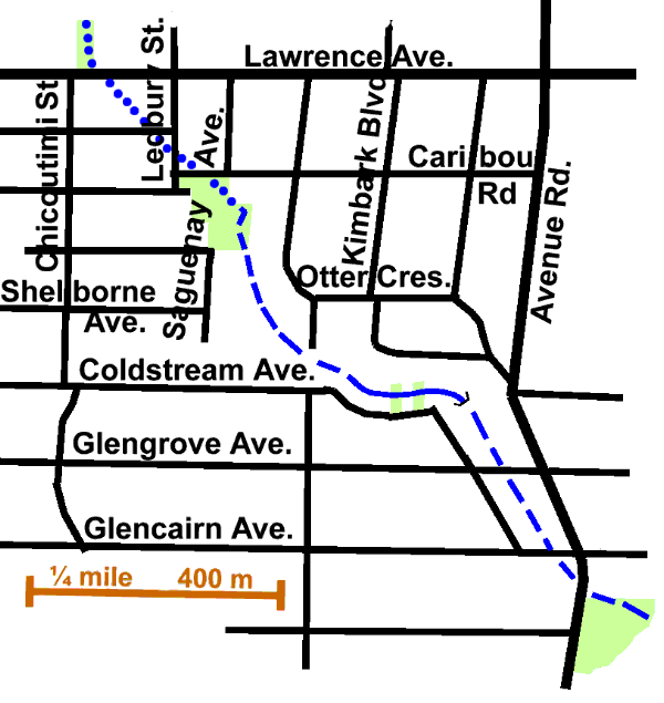
There are two ways to reach Avenue Road from here. To follow along the south west side, leave Caribou Park by the trail at the south-west corner to Saguenay Ave. and follow Saguenay south to where it ends in a cul- de-sac. The ravine can be glimpsed behind the houses on the east side of this street. At the cul-de-sac, you will then be at the boundary between the former Cities of Toronto and North York. In the back yards of the lots to the south notice a small stand of fair sized basswood with the odd black cherry, red oak and white pine. Return to Shelbourne, walk west to Chicoutimi St. and south to Coldstream Ave. Follow Coldstream east. The old City boundary is marked by a change from soft street edges to cement curbs. From numbers 115 to 51, Coldstream Ave. skirts the ravine. Two small parcels of public land in this stretch allow a view of the water course.. Continue south to Glengrove Avenue and out to Avenue Road. Note the low ground behind # 252 and the houses on the west side of Avenue Road where one can enter a lane to get a closer view of the ravine.
Tree cover in this area is light to moderate and chiefly dominated by Norway maple, but some blocks such as Chicoutimi have Austrian pine and Colorado spruce. The ravine trees are mostly crack willow with Norway and Manitoba maple, some white pine and hemlock. Other common trees are elm, Norway spruce, cedar, linden, honey locust, white birch, Scots pine, ash, silver maple, and black locust. Yellow birch, butternut, sumac, weeping willow and mountain ash are also found.
For the route along the north east side, leave Caribou Park by its northeast corner, follow Caribou Road to Otter Crescent, then Otter to Kimbark Blvd. The main street tree here is silver maple, but other trees include cedar, black locust, sugar and Norway maples, Scots and Austrian pines, linden, Norway and Colorado spruces, white birch and elm. Enroute, take a side trip down Glen Willow Pl. At its end, there is a small grassed area sloping down into the ravine to a ditch emptying into a storm sewer grate. This is the beginning of a sewer which flows to the North Toronto Storm Trunk Sewer in the Burke Brook valley. Notable trees in this ravine include crack willow, elm and weeping willow. Scots pine dominates the first block of Kimbark, along with black locust, Colorado spruce, catalpa, and silver maple. The ravine can be seen behind the interesting stone house at the bend. Along the second block of Kimbark, which brings us to Avenue Road, tree cover is light and includes red oak, white pine, black locust, crabapples, and silver maple. The valley, about six metres deep here, is visible to the south west behind the houses.
Walk south on Avenue Road to Glengrove Ave. Notice the relatively new row houses on the west side. They replaced small apartments built in the 1930’s similar to those in the next block south. Hurricane Hazel severely damaged the earlier apartments through flooding in 1957. Along Glengrove, the dip in the road to the west indicates the route of the Mud Creek valley. While it is physically possible to follow Mud Creek down behind the apartments forone block to Glencairn Avenue, this is private property and uninteresting. Cross at the Glengrove lights to the east side of Avenue Road and walk south, past Glencairn, to the set of steps leading down into the valley and Lytton Park. Continue on along the Lytton Park Reach.