2.1 km of Mud Creek though the Moore Park Ravine and the Don Valley Brick Works to the Don River. There is one small tributary Chorley Stream ( approx. 200 Metres).
This ravine passes through North Rosedale, Moore Park and Governors Bridge communities characterized by their large, older homes. Sanitary sewage from west of the ravine flows to the Ashbridges Bay Sewage Treatment Plant, but east of the ravine, it flows to the North Toronto Sewage Treatment Plant. Stormwater flows down this ravine to the Don River. One of Toronto’s Discovery Walks follows this ravine.
Proceed down the steep path into the Moore Park Ravine. As the path begins to level out, note a wider part of level ground on the west side of the trail. This is the site of the former Moore Park Station on the Beltline. The approach to the station was in a small park at the top of the west side of the ravine on Hudson Drive. This park while in the City of Toronto was owned by the Borough of East York. A walkway joined it to the station. Notice flowing water from springs behind the station site. Fine native trees growing in this ravine include white and red oaks, sugar and red maples, beech, black cherry and American elm, but there are far too many invasive trees such as Manitoba and Norway maples and crack willow. White birch, hemlock, white pine, black locust, aspen, cottonwood, ironwood and silver maple are also present. The City has started a program to remove some of the less desirable trees in order to favour better natives.
Click here to see sewers. Double click to remove.
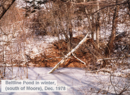
A small pond, formed by the railway trackbed (picture) lies on the east side of the trail. While fine mature oaks, beech and maples surround it, invasive exotics have over-shaded the pond and caused erosion problems. This is a small restoration project site of the Task Force to Bring Back The Don. Recent planting includes hemlock, shrubs and wild flowers. Half the pond is on land owned by a citizen who is co-operating with the City in this project. For more about this project, see http://www.toronto.ca/don/belt_line_pond.htm
Just past the pond on the west side one can see the outlet of the storm sewer which brings water from the Cudmore Creek as mentioned when we passed through Mount Pleasant Cemetery.
Next we pass under the Heath Street Pedestrian Bridge. This is the third bridge. In earlier years there was a wooden trestle originally for road traffic, which, when it became unsafe for vehicles, was used for foot traffic. Around 1960 it was replaced with a cement bridge. This was replaced in 1999 with the present structure. Further down the trail, notice where housing encroaches on the valley and construction debris scars the slopes.
Watch for storm sewer outfalls from neighbouring communities. The creek is sometimes on the east and sometimes on the west side, passing under the trackbed in culverts. Just before walking under the CPR railway bridge, we pass the shoreline of glacial Lake Iroquois. The CPR follows the old beach for several mile from the Junction in West Toronto to Leaside, as it was a good level stretch on which to construct a rail line. While the shorecliff is not visible from the trail, notice that the valley walls are not as high south of the bridge. Again, more houses encroach on the valley.
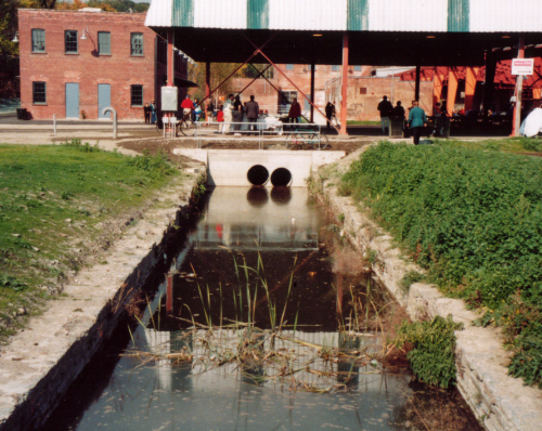
The next bridge is Governors Bridge, named when the Lieutenant Governors of Ontario resided at Chorley Park. Two communities located on the Iroquois terrace, Rosedale and Governors Bridge, are joined by this bridge. Just before we reach the slope up to Chorley Park, we begin to see the opening for the Brick Works through the trees. Here the creek is diverted into the Brickworks ponds. A culvert though the walls takes the base flow, but when a major storm occurs, extra water flows into the old storm sewer taking Mud Creek water directly to the Don River. From below, water is seen flowing out of the culvert into the first pond. Enjoy the panorama view of the brickworks and its ponds. Avoid the steep path from this lookout down into the Brick Works, and return to the main path, following it through the grove of Aspen, and along the Beltline Trail path bordered by Sumac to where a wide trail leads down into the Brickworks. West of this section a short stretch of Mud Creek can be seen above ground and small tributary Chorley Stream that comes down from the park.
Enter the Don Valley Brick Works Park near the buildings, and wander back along the trails to explore this developing park and its series of ponds. One can also trace the water of Mud Creek through a channel between the buildings and down to where it goes into a culverts again, under Bayview Avenue and under the CNR. The walk ends here at this culvert and does not cross the road. The creek passes under the Bayview Extension and the CNR tracks. Vehicle traffic along Bayview Extension is hazardous and railway lands are out-of-bounds (see railways are very dangerous). Mud Creek water comes out of the last culvert into an “S” shaped channel with riffles taking it down to the Don River among the willows. The outlet of the Mud Creek storm sewer we saw by the main trail below Chorley Park is just beside the stream channel.
Evergreen, an environmental group, is negotiating with the City and raising funds to “transform the Don Valley Brick Works, from a deteriorating asset to a thriving environmentally-based cultural attraction.” Go to evergreencommons for an outline of their plans.
The Brickworks area is poorly served by public transportation. One has several choices, all entailing some walking with hills to climb. The shortest route is back along the Beltline trail and up the steep hill to Chorley Park. The TTC bus stop at Douglas Drive and Glen Road is at its northwest corner. Another choice is to retrace back along the Beltline Trail through Moore Ravine to the weekday TTC bus on Moore Avenue. A third option is to proceed south on the Beltline Trail and up Milkman’s Lane to the Sherbourne bus. A pleasant walk through South Rosedale leads to the Castle Frank Subway Station as outlined at the end of the Park Drive Reservation Reach page.