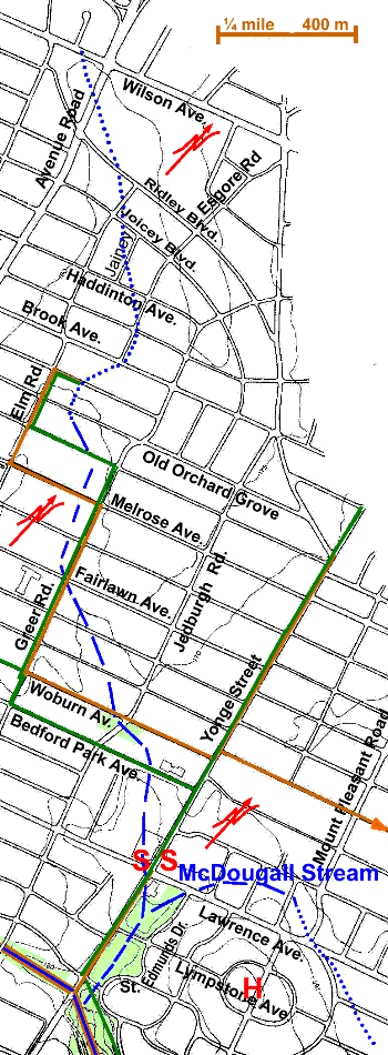
3 km tributary of Burke Brook, plus McDougall Stream, 1 km
From a source in the vicinity of Avenue Road and Wilson Avenue it flowed south-east to join Burke Brook in the present location of Alexander Muir Memorial Park, near Yonge and Laurence. North of Brooke Ave., it was in the former City of North York; from there south in the former Town of North Toronto. For the most part, its route passes through residential area with commercial development along Avenue Road and Yonge, and parts of Wilson, and Lawrence. Sanitary sewerage flows to the North Toronto Sewage Treatment Plant. Storm water from the north part flows to the West Don. In the south part, storm water flows to the North Toronto Storm Trunk Sewer (Burke Brook). It had one short (1km) tributary, McDougall Stream.

The route of Lawrence Park Stream can be traced starting with a slight dip in Wilson at Avenue Rd. Walk south to Ridley Blvd., east to Elm Rd., south to Joicey Blvd., east to Jainey Pl., south to Haddington Ave. east to Esgore Rd., and south to Brooke Ave., crossing several dips in the terrain along the way marking this stream’s course. This stretch is in the former City of North York. In the early part of the twentieth century, there was an airfield nearby just north of Wilson Ave.
Starting From just south of Brooke Ave., its route was in the former Town of North Toronto. From Esgore Rd., and Brooke Ave., go east to Greer Rd. which should be followed as far as Woburn Ave. Down to Fairlawn Ave. the valley of Lawrence Park Stream can be seen along the cross streets to the west. At Fairlawn Ave. it crosses the corner of the John Wanless Public School grounds and then across Greer. For the next two blocks it is visible to the east. At Woburn go east to Jedburgh Road, where there is now a small park on filled land. Lawrence Park Stream crossed the park area from north-west corner to south-east corner. Walk south to Bedford Park Ave. and then east to a Dominion Store parking lot. The valley crosses just west of Blessed Sacrament Separate School. Walk through the parking lot or directly east to Yonge Street and south. The stream’s course is marked by a sunken courtyard in the building on the north-west corner of Yonge and Lawrence, and low spots on these two streets.
Walk to the south-west corner of Yonge and Lawrence and into Lawrence Park south of Locke Library. North of Limpstone Ave Lawrence Park is naturalized to some extent with mown grass in the centre: White Pine, Linden, Norway & Silver Maple, Crack Willow, Basswood, Black Locust, Mulberry and Ash of fair size line the slopes of the small valley. McDougall Stream joins Lawrence Park Stream here. South of Limpstone Ave., both the east and west slopes have been naturalized. The west side was planted in April 1996 by The Task Force to Bring Back The Don: Silver Maple, Ash, Larch, Manitoba Maple & shrubs (Dogwood etc.). Crack Willow & Norway Maple are found in the centre of the park. On the east, there are Scots Pine, Black Cherry, Aspen and White Pine. South of St Edmonds Dr., Lawrence Stream joined Burke Brook in the middle of where Alexander Muir Memorial Gardens is now located. Carry on down this ravine to enjoy the Sherwood Reach.
McDougall Stream
McDougall Stream, a short 1km tributary to Lawrence Park Stream, started near St. Ives Cr. and flowed north-west to Mount Pleasant & Lawrence, circled north of Lawrence (note dips in Preston Pl., Cardinal Pl., & Leith Pl.), crossing Lawrence again to enter the NE corner of Lawrence Park. A plaque to Wm. McDougall, 1822 to 1905, one of the fathers of Confederation is found here. The tree cover and housing is typical of North Toronto. The park is partially naturalized with White Pine, Linden, Norway & Silver Maple, Crack Willow, Basswood, Black Locust, Mulberry and Ash. It joined Lawrence Park Stream between Lawrence & Limpstone.
