2.3 km of Burke Brook, from Yonge Street to Bayview Avenue
Its path went through three former municipalities: The Town of North Toronto, The City of North York and the Borough of East York. In the lower half of this reach, we walk through Sherwood Park which has one of the finest stands of native trees in the central city. Storm water still flows through Burke Brook, or as it is known in this reach now, The North Toronto Storm Trunk Sewer. Sanitary sewage flows to the North Toronto Sewage Treatment Plant in the Don Valley via the Forman-Yonge Combined Trunk Sewer. One of the City’s Discovery Walks, “Northern Ravines and Gardens,” follows this reach. Two tributaries Lawrence Park Stream and Blythwood Stream joined Burke Brook in this reach.
Click here to see sewers. Double click to remove.
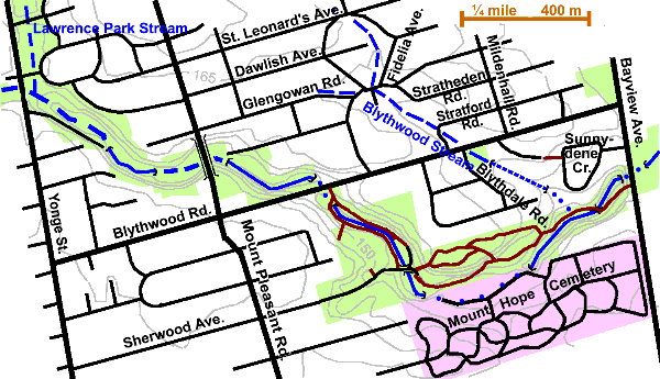
Start at Alexander Muir Memorial Gardens, which is on the east side of Yonge Street, two blocks south Lawrence Ave. This formal garden, noted for its roses, was established in memory of the writer of the patriotic song, “The Maple Leaf Forever.” It was originally established across from Mount Pleasant Cemetery, but was moved to this site at the time the Subway was constructed. There are quite a few trees including: Honey Locust, Scots Pine, Cottonwood, Red Oak, White Birch, Sugar and Norway Maples and Linden. The two trees noted in the formal garden were Chameacyparis & Juniper. Lawrence Park Stream originally joined Burke Brook in this park.
Continue on through the park, past the tennis courts. Here Burke Brook comes out in a channel. While we like to think of this channel as Burke Brook, it is formally known as The North Toronto Storm Trunk Sewer. The ravine bottom is level and grassed with Crack Willow and Manitoba Maple along the channel. There are occasional Silver Maple, Linden and Ash. The slope woodland is variable with: White Pine, Manitoba Maple, Honey Locust, Norway Maple, Cotton wood, and Black Locust. The channelized version of Burke Brook continues down the ravine for over a kilometre into Sherwood Park, except for short distances at the Mount Pleasant bridge and at Blythwood Dr., where it is in a large sewer (1800 mm x 2100 mm twin). There is some naturalized area and recent planting both above and below Mount Pleasant Bridge including: White Pine, Tamarack, Red Oak, Linden, Silver Maple and Austrian Pine. The woodland is a bit more open past the bridge and includes: Sumac, Mulberry and Walnut. Manitoba Maple is plentiful.
Crossing Blythwood Drive, we enter Sherwood Park with its outstanding stands of native trees. Steep slopes are covered in a rare old growth forest, which has experienced severe stress from heavy urban use. This is a heavily used city park and thousand of people and their pets visit it every year. The City has appointed an advisory committee and worked with it to advance plans to reconcile the needs and desires of the different users. “The goal is to restore natural vegetation and maintain the ravine in its historic natural character while maintaining it as a usable public space.” See The Sherwood Park Forest.
Walking down the main trail from Blythwood, one reaches the point were the stream again comes out of the sewer into a man made channel. Here we can take trails along either the east or the west side. Following the east side, we traverse the grassy valley bottom, but note the fine forest on the hill; a mixed woodland with confers (White Pine and Hemlock) and hardwoods (Beech, Black Cherry, Sugar Maple, Ash, Red Oak and others). We pass throgh a cluster of White Pine and Ash left in the grassed bottom and past a couple of naturalized areas. At the bridge we see the park maintenance buildings. This is the site of the Town of North Toronto’s waterworks. Two routes one can be taken from here.
Following the channel we see that the brook goes underground at the edge of the park into a sewer under Mount Hope Cemetery. In earlier times the stream flowed through several ponds on the cemetery grounds. Following the lower park path through the hardwood stand, one finds the stream coming out of the sewer again as it returns to the park.
Following upper paths we pass through the best part of the Sherwood Park forest, with many fine old trees: Red and White Oak, White Pine, Red and Sugar Maple, Black Cherry and others (up to 130 vegetative species in all). Much of this park is fenced to protect the ground vegetation and so prevent erosion.
The trails join and become a boardwalk. Note the presence of springs. Shortly after leaving the boardwalk, near a slight bend in the stream, note the manhole and sewer outfall. This is where Blythwood Stream enters Burke Brook. The woodland changes to Willow Aspen Sumac Ash Manitoba Maple and Elm. A side trail can be followed along the stream to where Burke Brook again goes into a sewer to pass under Bayview Ave. The main trail climbs to Bayview Avenue, which one can cross to continue on through the Sunnybrook Ravine.