2.5 km of Yellow Creek, from Forest Hill Memorial Park to Yonge St.
From Memorial Park Yellow Creek flowed south east to cross Yonge Street at Mount Pleasant Cemetery. This reach lay in the former Village of Forest Hill and former City of Toronto (touching the south-west corner of the former Town of North Toronto). Sanitary Sewage flows to The North Toronto Sewage Treatment Plant in the Don Valley via the Balliol Combined Trunk Sewer. A major storm sewer follows old creek course. The Beltline Railway followed this stretch of Yellow Creek. The Central Ravines, Beltline & Gardens Discovery Walk follows the Beltline here. Yellow Creek is traced along The Beltline, through Oriole Park and the TTC Davisville Yards to Yonge Street and Mount Pleasant Cemetery.
Click here to see sewers. Double click to remove.
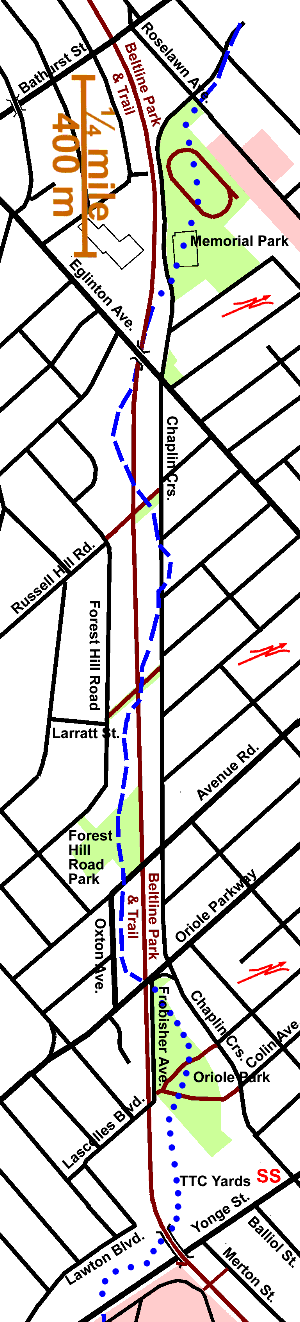
Start at Roselawn and Chaplin and walk south through Forest Hill Memorial Park to the Beltline. There is a large storm water holding tank under this park. Crossing Chaplin to the Beltline Linear Park note ornamental crabs and traffic calming measures. South of the west end of Memorial Park there are some planted Red Pine & Burr Oak. Walking south-east along the Beltline, note several small ecotypes: In the open areas there are vetch, buttercups, goldenrod, vines, thistle, sow thistle, Queen Anne’s Lace, burdock, dogwood & grasses. In the small wet areas along the former track can be found Sandbar & Peach Leaf Willows as well as cattail, buttercups, and Silver Maple. More brushy areas have Tree of Heaven, Manitoba Maple, Norway Maple, Hawthorn, Japanese Knot Weed, Ash Elms and vines,
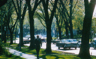
Passing under the Eglinton Avenue Bridge, we enter a wooded stretch of the Beltline where we walk through a tunnel of Norway & Manitoba Maples, native & exotic Elms and other trees. Norway Maple & exotic Elms are invasive exotics. Watch where the Beltline crossed Yellow Creek. It did several times along this stretch. Examples of Dutch Elm Disease may be seen. There are some planted Red Maple & Hemlock near the bridge. Just before the Russell Hill Road foot path there is a larger mulberry and between the Russell Hill Road foot path and the Larratt Crossing, Walnuts, White Birch Mountain Ash & Ironwood; Mulberry near planted Red Maple & Red Oak (picture of tracks)
Forest Hill Road Park can be seen on the south side, just before reaching Avenue Road. Trees in this park include: Ginkgo, Walnut, Colorado Spruce, Yew, Siberian Elm, Hard Maple Basswood Crab Apple, Willow, Norway Maple, and Silver Maple. The small building in this park houses the junction of the Forest Hill Sewer System with the main sewer to North Toronto Sewage Treatment Plant. This is a good point to discuss how sewers are frequently located in the beds of former streams, because the course of the stream has an excellent grade.
Crossing Oriole Parkway and, further on, Avenue Road can be difficult; it is recommended that one walk north to take the lights at Chaplin Cr. Between Oriole Pkwy and Avenue Road one can see that the lowest spot where the stream ran was on the south side of the Beltline along Oxton Ave. Trees along this stretch include Norway & Manitoba Maples and Cottonwoods, some of which were lost in the ice storm of December 1992. Small trees planted here include Beech, Sugar Maple, Crab Apple, White Pine, Red Oak and Cedar. Grapevines are also prevalent.
The vegetation along the Beltline beside Frobisher Ave., includes several invasive species: Norway & Manitoba Maples and Japanese Knot Weed. Vines: grapevine Virginia Creeper. Planted trees are: Sugar Maple, Silver Maple, White Pine, White Spruce, Ash, Basswood, Bur Oak, Red Oak, Mountain Ash. Other trees: Elms, Pear, Poplar, Cedar, Crab Apple, Cherry, & Yew.
Oriole Park is one of those many parks created on former garbage dumps. The stream came into this area following the Beltline and, according to one map, swung to the north edge of the park area. There is a bit of a ditch there now and some willows, but the steam ran in a much deeper valley (shown on some old survey maps), matching the depth at Yonge street. Many of the trees in this park were planted in 1967 to mark Canada’s Centennial, including a number of the Confederation Crab Apples.
From the ravine where the park is now, Yellow creek flowed through the present position of the TTC Davisville Yards and crossed Yonge Street into Mount Pleasant Cemetery. Oriole Park can be reached from Davisville Subway Station by walking west along Chaplin Cres. and south though a foot path south of Colin Ave. At one time before the Dutch Elm disease, Chaplin was arched over by the American White Elms growing along both sides of this street. Trees in this park include: White Ash, Honey Locust, Sugar, Silver, Norway & Red Maples, Linden, Elms and White Pine.
Follow the Beltline from Frobisher to the bridges over the TTC yards and Yonge Street; beside the Brentwood Towers, one of the early high-rise apartment developments. The trail is lighted by park lights especially designed for the Beltline Park, and is lined with Cottonwoods, Manitoba Maple and Siberian Elm. Burdock is a plentiful component of the ground cover.
At the bridge over the TTC yards pause and look south to see the low spot on Yonge street where Yellow Creek crossed over to Mount Pleasant Cemetery. There are records of several sawmills on Yellow Creek. One, at about this location, in what is now the south end of the TTC Davisville Yards, is mentioned by Henry Scadding’s in his book, “Toronto of Old.” Scadding also mentions a pottery, Whitmore’s Pottery Burned in 1830 and taken over by John Walmsley. An old map shows a brewery was in this area. Before the subway was built, Alexander Muir Memorial Garden was located on the west side of Yonge Street across from Mount Pleasant Cemetery and Yellow Creek flowed through it.
Continue along the bridge across Yonge Street and enter Mount Pleasant Cemetery by the gate just east of Yonge St. to continue down Yellow Creek along the Vale of Avoca Reach.