The topography in this park and its ravines, has been profoundly altered by the construction of the subway, and the Spadina
Storm Trunk Sewer which run under it. Further down the valley we see a stream that looks as if it has been there for ever. Not true, This small stream and associated wetlands have become established on top of the fill over the subway line. What is seen here gives hope for the success of other natural area restoration. There are problems including invasive exotics and the loss of the original vegetation, but nature is resilient. In many situations all we need to do is protect from disturbance. In some situations removal of some undesirable trees and ground plants, followed by planting native trees and wild flowers, will help speed the process. The Task Force to Bring Back the Don is planning some small restoration projects for suitable spots in this ravine.
Cedarvale Ravine
If you are at Arlington Ave. coming from the upper reaches, go east behind the arena and pick up the trail on the north slope leading down the valley. If have come down from Eglinton as suggested above, you are now at the emergency subway entrance at the top of the slope looking down. Castle Frank Brook flowed into the park from behind the Arena to met Cedarvale Stream here. Note the group of large old White Oak on the slope to the west of the subway emergency entrance.
Click here to see sewers. Double click to remove.
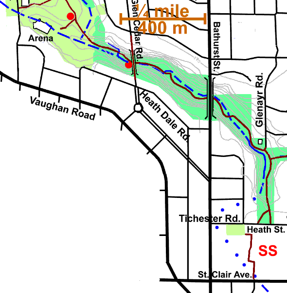
Follow the paved path east to the valley bottom. It becomes a gravel path shortly. Planted trees along the way include: Aspen, Ash, White Spruce Red Maple and Sumac. Manitoba Maple is also present. On the upper valley slopes, oaks and other fine old trees become noticeable as is typical of the Castle Frank Brook ravines. We pass a small bridge over a small stream. It flows into a small wetland seen just before we pass under the Glen Cedar Bridge. Toads are known to breed in this small pond. (See frog song survey) Crack & Weeping Willows, White Spruce, Red Maple, Cockspur Hawthorn, Ash, Red Osier Dogwood, Cattail, Narrow Cattail, Joe-Pye-Weed, Milkweed, Willow galls.
Passing the Bathurst Street Bridge, we enter an more open area with scattered willows and lots of Cattails and some Purple Loosestrife. Springs are more prevalent in this part of the valley. At one time there were quite a few “allotment” gardens on the north side of the trail. In drier areas, stands of Cockspur Hawthorns and Black Locust are found. This part of the ravine was in the Former Village of Forest Hill.
Passing a Hydro Substation, see pond with Flags and Duckweed. More Manitoba Maple & Elm; also Norway Maple, Norway Spruce, White Spruce, & dogwood. The Glenayr entrance to the ravine is here. Note White Pine on valley slopes. Pass side ravine and Spadina Storm Trunk Sewer Manholes # 16 A B C D, where Forest Hill Stream joined Castle Frank Brook.
Continue on down the valley and up the path to Heath Street West. A number of pioneer tree species such as Poplar, Ash Norway Maple, Sumac & Hawthorn can be observed. Hardwoods and White Pine can be seen on the west side slope. Black Locust occurs at the top of the east side.
On reaching Heath Street West, one could take the Subway from the St. Clair West Station or continue down Castle Frank Brook valley through the Nordheimer Ravine. Return to the Cedarvale Reach page for details.