1.4 km of Taddle Creek
Walking west from Avenue Road along the south side of Bloor Street, just west of the Royal Ontario Museum one finds an elaborate structure with stone pillars and serpent-headed, wrought iron lamps. This is the Queen Alexandra Gateway, which now marks the north end of Philosopher’s Walk and a stretch of the Taddle Creek valley that is still visible. This is the beginning of the University Reach. Taddle creek passed through what is now known as the St George Campus of the University of Toronto and then south just west of University Avenue, then known as College Avenue, to cross that street at Elm Street. Along this stretch of University Avenue there are now several of our greatest hospitals. As we follow this stretch, we will see many of the fine buildings that grace the university campus. Only a few will be discussed. To find out about more about the campus and its buildings, we suggest going to these sites:
- http://www.utoronto.ca/openspace/
- http://www.greatspaces.utoronto.ca/
- http://www.doorsopen.utoronto.ca/
The campus is well treed and University Avenue has trees planted along the boulevard and in the central strip. There are some quite ancient oaks in Queen’s Park. Storm water flows to Toronto Bay and sanitary sewage to the Ashbridges’ Bay Treatment Plant.
Run your mouse over map to see hot spots to points of interest.
Click here to see sewers. Double click to remove.
Click here for 1860 Campus. Double click to remove.
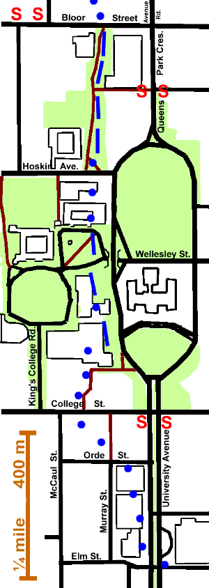
Walk south through the Queen Alexandra Gateway and along Philosopher’s Walk. On the left, is the original wing of the Royal Ontario Museum and on the right McMaster Hall the first home of McMaster University and now part of The Royal Conservatory of Music. This small valley was the subject of a movement to “Day light” Taddle Creek. It failed due to the inability to find a satisfactory source of water. One source examined was using rain water from the roofs of nearby buildings. Unfortunately this would generate an extremely variable stream, from strong flow during a storm to no flow at all. This would result in a string of stagnant pools; not an attractive result. For more about this project go to: Taddle Creek Project. This is also a good source for more information about Taddle Creek. In 1852, a plan was drawn up for a Botanic Garden along Taddle Creek. “The land for this proposed garden consisted of a strip about one hundred yards wide, running down the ravine from Bloor Street to the University Pond.” Nothing came of it, because the Experimental Farm and Department of Agriculture, of which it was to be part, was discontinued.
As we reach Hoskin Avenue, we pass Trinity College on our right. Trinity was originally an independent University with its campus along Garrison Creek. A new “gate” at the south end of Philosopher’s Walk was constructed in the spring of 2006.
At Hoskin, Taddle Creek disappears underground. While there is more than one way to follow it down to College Street, this time we will take Queen’s Park Crescent. Passing Hart House the valley is visible again on our right almost to College Street. Note the tower at the far end of Hart house. This is Soldiers’ Tower, a memorial to the 1,180 men and women lost to the University in the two world wars of the twentieth century. It is the second highest war memorial in Canada. For more about Soldiers’ Tower, go to virtual tour. Across the valley one can see University College. At one time it was the main University building. Next, on a small hill overlooking the Taddle Valley, we will pass another memorial. It is called the Volunteers Monument and commemorates those who fell fighting the Fenians.
On our left is Queen’s Park and the Provincial Legislature, the latest of several Parliament Buildings in Toronto.
The valley is seen, threading its way past the Gerstein Science Information Centre , which was the main library for the University before the Robarts Library opened. For more about Gerstein Library see U of T website We then pass the Medical Sciences Building. In early days, The Faculty of Medicine was housed in a Greek revival brick building similar to King’s College, constructed in 1850 on the east side of Taddle Creek, about where the south-east corner of the Medical Sciences building is now. This building was used in mid 1850s to house the University, pending the completion of the UC building, as the Faculty of Medicine had been abolished. For more about this see U of T history. A map of the campus in 1860 can be seen by clicking the margnial note next to the map above.
At the Medical Sciences Building, the Taddle Valley disappears and little sign of it will be seen until we approach King and Parliament. Take the path just south of the latter west and south to College Street. Taddle Creek crossed College Street just west of this path. Notice the interesting Victorian Gothic building across the road, Toronto Athletic Club. In earlier years, Sleepy Hollow, the home of John Beverley Robinson, was located at this spot.
Walk east to University Avenue. At College Street and University Avenue, note the Ginkgo tree on the NW corner. It is believed to be the first Ginkgo planted in Toronto. On the NE corner is the Ontario Fire Fighters Memorial. Walk down University Avenue to Elm street. Caer Howell, the W. D. Powell mansion, was at the SW corner of University and Orde St. South of Caer Howell, on the east side of College Avenue (an early name for University Avenue), west about 200 meters and south nearly to Dundas, was an early site of the CNE.
On this stretch of University Avenue several of our greatest hospitals are located. Toronto General Hospital; the third TGH building may be seen on the south side of College Street and more recent hospital structures on the east side of University. South of these at the corner of University and Elm is the present “Sick Kids” Hospital. On the west side of University are Princess Margaret Hospital, Mount Sinai Hospital and Toronto Rehab.
At Elm street one can continue along the St Patrick Reach.