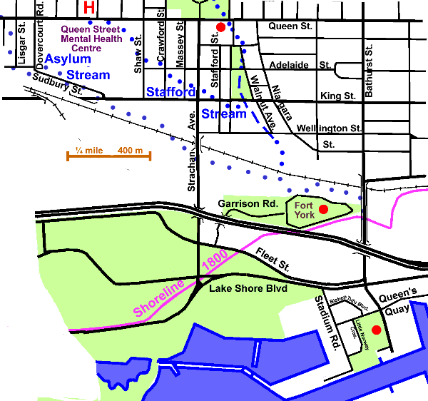
1.3 km of Garrison Creek from Queen Street to Toronto Bay, plus Asylum Stream, 1.5 km and Stafford Stream, 0.5 km.
The Fort Reach is a highly industrialised part of the city. Besides industrial and commercial areas it also includes some residential and mixed use areas. Except in Stanley Park, the former courses of Garrison Creek and its tributaries are in the main not discernible. The tree cover varies from nil to fair. It was entirely within the early City of Toronto. Most storm water enters the lake by combined sewer overflow outlets. Sanitary sewage flows to the Ashbridge’s Bay Sewage Treatment Plant via the High Level and the Low Level Interceptor Sewers. The Garrison Creek Discovery Walk follows this reach.
Click here to see sewers. Double click to remove.
Start at Queen St. and Walnut Ave., but before walking down Walnut, go a bit west to 901/911 Queen St. which is a fine example of early Toronto architecture. It is a red brick house, standing a bit back from the street, and is now the office of “Trinity Lofts.” Farr’s Brewery was located nearby on the west bank of Garrison Creek, just south of Queen. Proceed down Walnut to Stanley Park. Check sewers and apartments. Note the round plaques with animals in the side walks and the monument to Garrison Creek.
One of the Garrison tributaries, Stafford Stream, which is now largely invisible, met the main stream just south of King St. It started on the grounds of the Mental Health Centre close toOssington and Queen. There is a slight dip where it crossed King St. at Stafford St.
South of the park the low area marking the creek disappears into an industrial area. From here on the route of Garrison Creek is invisible due to railway and industrial development.
Asylum Stream, another lost tributary of Garrison Creek, joined it where railway tracks now run. This stream started near Queen and Lizgar and crossed a corner of the Queen Street Mental Health Centre, formerly the provincial asylum, thence the name. It ran through area now much changed by industrial and rail development. No trace was seen. (Ian Wheal tells me that this stream started further north near Beaconsfield and Afton Avenues in the Dovercourt Swamp, which lay to the west between Dundas Street and the railway tracks.)
Go east on Wellington St. to Niagara St, which parallels the stream route for a bit, take the latter to Bathurst St. There are quite a few interesting old houses and industrial buildings on Niagara. Walk south on Bathurst St to Fort York. Garrison Creek entered the bay at the fort which is located at the original shoreline.
You can follow the Discovery Walk south on Bathurst to Little Norway Park on the Western Gap, marking the location of a World War II training camp where men who had escaped from Nazi occupied Norway were trained as airmen. This was part of the British Commonwealth Air Training Plan, a major Canadian contribution to the war effort. It involved the creation in Canada of an enormous training organization, including at its peak 97 flying schools and 184 other units. By March 31, 1945, when it was closed down, the plan had produced 131,553 aircrew personnel for the Commonwealth and allied countries, a tremendous contribution to victory.