Click to see sewers. Double click to return.
1.2 km of Mud Creek from Roselawn Avenue to Yonge St., including the tributary, Willow Creek, 1 km
This reach, in the former Town of North Toronto, is now mostly residential with some commercial development along Eglinton and Yonge. The north portion is in Eglinton Park. Most stormwater flows to Yellow Creek and sanitary sewage flows, via the Avenue Manor Combined Trunk Sewer, to the North Toronto Sewage Treatment Plant in the Don Valley. St Clements Stream, which is described under the Lytton Park Reach, entered Mud Creek in Eglinton Park,
Click here to see sewers. Double click to remove.
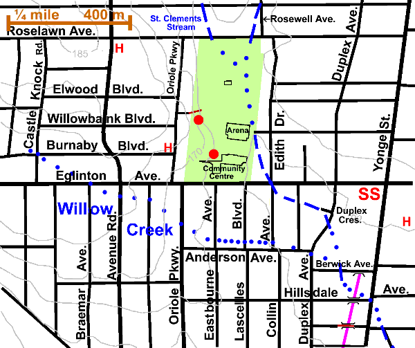
Beginning at Rosewell and Roselawn Avenues, walk south through Eglinton Park. This is the site of Pears Brickyard, established in 1885 to manufacture bricks. The City of Toronto purchased it for parkland in 1926. The Yorkville Brick Yards page gives further information on other brickyards operated by the Pears family. The park’s shape and location in a valley are characteristic of Toronto parks located in former brick yards or sand pits. Early photographs show Mud Creek in the background of the Pears Brickyard, but it is unclear today exactly what route the creek followed and if any of the original bank remains. The ditch and sewer grate along the fence on the east side of the park are all that remain of the creek.
Farmland surrounded this area from the 1830s to the early 20th century, when North Toronto was subdivided for urban development. James Lesslie, then his son-in-law John Gartshore, owned the land north of Eglinton and west of the park. The Lesslie farm was called “The Willows”. Springs in the hill fed willows that grew almost to the top of the hill.
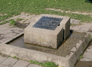
Other notable stopping points in this park include Eglinton Park Hill (from the west side of the park to the other side of Avenue Rd.), the The Naturalized hillside, the North Toronto Community Memorial Centre and The Eglinton Park Heritage Community Garden. Many plants grown by first nations people and early settlement farmers are grown in this garden. To bypass these and simply follow Mud Creek, take the path on the east side of the park south to Eglinton. Honey locusts, Norway and sugar maples, ash and lindens border this path. About halfway along, notice a small grove of sugar maple. If one is walking with a canine companion, a small detour to the dog drinking fountain established in honour of Judge Joe Addison and his dog Max is a highlight. Past the arena, you will see that the low area marking the course of the former stream is now to the east of the path and that by the time we reach Eglinton, it is about a block away.
According to verbal reports from residents and staff, drainage problems recur at both the Community Centre and the apartment building on Edith Ave. just east of the park. This is a symptom of a river trying to remake itself. Natural processes continue to supply water, but the creek is no longer exists to remove seepage from those valley walls and springs.
Walk to the southeast corner of the park, cross Eglinton with the light at Lacelles Blvd. and walk east to Duplex Avenue. The low point on Eglinton is about where the creek crossed. Notice the sewer outlets on the street at this point and the willow on the grounds of the apartment building at Edith Ave. As you get to Maxwell Street, you will be able to follow the topography of the creek by looking for the low land which runs past the south east corner of the apartment building on the east side of the street. Continue east on Eglinton and turn south on Duplex. The curve in Duplex and the cul-de-sac on Duplex Crescent are typical of the kinds of street patterns created by former streams. Mud Creek probably ran behind Duplex Cr. and crossed Duplex Avenue near a low point in the road at the curve. As you continue south on Duplex, notice the terraced front yards where the ground rises on the east side of the street. The line of low points defining the creek bed runs southeast on a diagonal across Duplex above Berwick Avenue.
Willow Creek
Willow Creek, a tributary which appears on a1927 military survey map, arose northwest of Avenue Rd. and Eglinton near Castle Knock and Burnaby Blvd. The creek crossed Eglinton at Braemar Avenue, then Avenue Road, Highbourne Road and Oriole Parkway, abit south of Eglinton. Willow Creek then flowed easterly north of Anderson Avenue to Mud Creek near Berwick and Duplex. A few traces of this stream may exist behind houses on Anderson Avenue.
Continue down Duplex to Hillsdale. Looking east on Berwick, note the low spot and the willow behind #45. Walk east on Hillsdale. Notice the style change at houses #53 and 57 showing two distinct periods of North Toronto house construction. One can also see the large willow behind the house # 40 mentioned above. Cross the bridge over the subway. Mud Creek crossed Yonge Street at Hillsdale. Look for Lost Rivers plaque in sidewalk, marking the crossing. This stretch of Yonge St. was difficult, swampy and made barely passable by a stretch of corduroy road. Turn south and walk to Manor Road, crossing to the east side of Yonge at the lights to continue on along the Davisville Reach.