1.5 kilometres of Yellow Creek from Mount Pleasant Road to Don River.
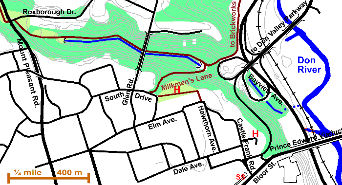
Park Drive Reservation Ravine (sometimes know as the North or Second Rosedale Ravine) derives its name from the closed road allowance called Park Drive Reservation. (Closed to public motor vehicles April 1973.) This road was used to access the network of roads in the Don valley prior to construction of the Don Valley Parkway and the extension to Bayview Ave. Things are not always what they seem. In this ravine, Yellow Creek is apparently seen in an open manmade channel, but this is really part of the Spadina Storm Trunk Sewer and carries water piped from Castle Frank Brook. The water from Yellow Creek flows in sewer under the path and enters the Don River just south of the DVP Bayview link. Close to the end of the ravine the Spadina Storm Trunk Sewer water enters a sewer under the Bayview/DVP/Bloor Street interchange, to join the Don River just north of the Prince Edward Viaduct. There are two small remaining sections of an old channel that used to cross the Don flood plain, to be found in the embrace of the interchange. This reach is located in Rosedale, one of Toronto’s old and classy neighbourhoods. Sanitary sewerage from houses in Rosedale flows to the Core Interceptor Sewer.
Click here to see sewers. Double click to remove.
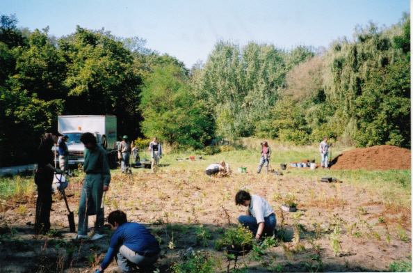
After crossing Mount Pleasant Road, follow gravel road down the ravine. To the north of Roxborough Drive and at the edge of the first open grassed area, we pass two examples of naturalization by planting and stopping mowing. The latter was planted in October 1995 by the Task Force to Bring Back The Don. In this latter restoration area, as well as planting trees and shrubs, logs and stones were placed among them to provide homes for small animals. Pass a stand of Balsam Poplar into another open area, where shrubs and wild flowers have recently been planted to encourage butterflies (2000&2001). (Picture) In the Toronto region, most restoration activities have the object of bring back the forest. Forest ecosystems were the norm for north eastern North America. Still there is a place for meadow ecosystems and this was chosen as one where meadow flora and fauna such as butterflies might well be nourished.
Shortly, on the right, we see the outlet of the Spadina Trunk Storm Sewer (built late 1960s) where water from Castle Frank Brook flows into the Yellow Creek valley. We will follow this channel to the end of the road. Under our feet is a 120 cm watermain taking the waters from The Vale of Avoca (Yellow Creek) to the Don River just south of the DVP Bayview link. There is also a 30 cm gas pipeline underground following this valley. About 800 metres on, there is a major combined sewer overflow point. Compare the upper slope forest of Oak & Pine with the Norway Maple poplar and exotic Elms that help stabilize the slopes of the new channel. Notice how the stream is trying to take a more natural form. Wildlife that maybe seen include ducks, red fox, racoons, chipmunks, squirrels and a variety of bird species.
Go under Glen Road Bridge. The original bridge was built in 1882 to join North and South Rosedale and was called the “North Iron Bridge.” At the end of the road the ditch ends and the water again goes into a sewer to flow under the highway interchange and enter The Don just north of the Prince Edward Viaduct. Notice the Sign Post and the Discovery Walk sign. Also to be seen here is a small wetland and some logs placed as to make micro habitats.
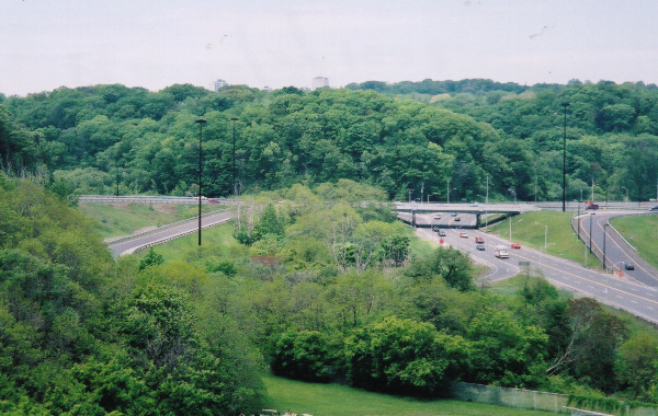
If you care to dodge highway traffic, you can visit the two small remaining sections of the old channel across the Don flood plain, left after construction of the highway interchange. Take the trail to the Brickworks to where one can easily step onto the interchange shoulders. Follow this “cloverleaf” around to the south “cloverleaf” which encircles the first lost section. Follow the latter “cloverleaf” around to its south end where one can cross over to the second lost section. (Click for picture) The woodland along these channels is not notable, being largely Manitoba Maple and exotics such as Ailanthus. One map shows Yellow Creek flowing directly to the Don River from the second section as shown on the map by blue dots.
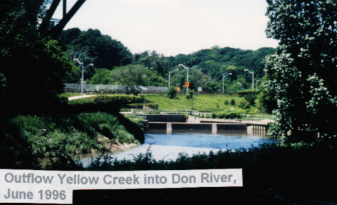
The best choice is to go up Milkmen’s Road, which acquired its name because employees of a dairy on the east side of the Don Valley used it to make deliveries to customers in Rosedale and the Village of Yorkville. It was open to vehicular traffic until 1958. The forest along this road, on the slope of the ravine is especially fine. Count the species of trees to be seen as we walk up (Sugar Maple, Manitoba Maple, Ash, White Birch, Beech, Oaks, Hemlock). At the top we reach Cragleigh Gardens. This park was donated to the people of Toronto by Sir Edmond Osler, a financier who had his home, Cragleigh, on this property. It contains many fine old White & Red Oaks. Cross Cragleigh Gardens to the south-east corner; and take the walkway to Castle Frank Road, which can be followed to Bloor Street. A couple of items to observe along this street are: the cluster of Kentucky Coffee trees at Hawthorn Gardens and the historic house at the end of Drumsnab Road, a private road. This house, Drumsnab, is probably the oldest house in Toronto that is still used as a private dwelling. Follow Castle Frank Road to Bloor Street and Castle Frank Subway Station. But before taking the subway home, go east to the Viaduct & look down on the north side to Yellow Creek’s outlet into the Don. (Click for picture) You can also see a bit of the two small remaining sections of the old channel across the Don flood plain, now surrounded by the highway interchange. (Click for picture)
Look over north and south sides of the viaduct to observe The Don’s wide valley.