Return to Don Channel Reach main page.
When the Town of York ( now the City of Toronto) was founded by Sir John Graves Simcoe 1793, the valley was covered with mixed forests, providing homes for animals and the river teemed with fish and waterfowl. As settlement progressed, the river and its valley became perceived as either resources to be exploited or obstacles to be overcome. In the early nineteenth century, forest land was cleared for farms and for the mills, powered by the river and its tributaries. The early twentieth century saw the marshes filled in for sanitary reasons and to facilitate port development. Lands adjacent to the river were developed for industry and residences, pollutants have ravished the river’s water quality and the valley was turned into a transportation corridor.
Click here to see river and bays as in the past. Double click to remove.
Click here to see sewers. Double click to remove.
From its inception, The Task Force to Bring Back the Don has pushed for reconnection of the Don River to Lake Ontario by a naturalized river channel and wetland. In the fall of 1997, the Task Force held a visioning session, out of which came the following declaration pointing the way to a natural river mouth.
An urban wilderness
A place of mystery, discovery, and spiritual rejuvenation;
A place to feel the fresh mud,
and hear the noises of ducks and other birds,
Insects, frogs, and children
Amid the hum and bustle of city life.
A web of wetlands, clean water, meadows, and trees,
Alongside businesses, offices, people’s homes,
And networks for transportation and communications.
A destination
Where people go to work or to have fun.
Where city meets nature,
And the river meets the lake.
Where opposites mingle and recognize that they are one.
A gateway
For fish and wildlife
Moving between the headwaters of the Don River and Lake Ontario,
For people
Travelling on the trails along the waterfront
And up the river valley
Or out to open water.
A large place
With space enough for people to find solitude
And for sensitive plants and animals to live and breed undisturbed.
A place that Toronto has adopted,
And neighbouring communities feel a sense of pride.
A place that simply is.
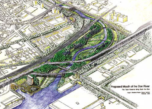
The Task Force also arranged for this picture to show how the Mouth of the Don might look.
Things started to happen, when in 2001, the three levels of government (Federal, Provincial and the City of Toronto) reached an understanding that Toronto’s waterfront must be cleaned up and that the Don Mouth Naturalization and Port Lands Flood Protection Project had to be part of this. Toronto and Region Conservation, in co-operation with the Toronto Waterfront Revitalization Corporation, is proceeding with preparation of plans to transform the existing mouth of the Don River including the Keating Channel, into a healthier, more naturalized river outlet and also to remove the risk of flooding to 230 hectares of urban land in this area.
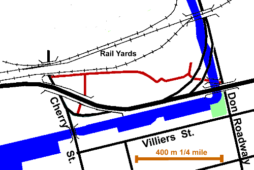
This will not be a simple matter. This is an important transportation hub, including major streets and highways, rail lines and port facilities. The city is mulling over: whether to take down the Gardener Expressway; what type of transit should serve the area; how to make the street pattern more effective.
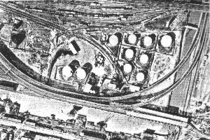
This is a contaminated area. In the beginning it was a marsh that was filled in with unspecified materials. Then it was an industrial area and a tank farm for petroleum products which occasionally spilled. With a porous soil and a high water table the spilled materials went down to the water and spread out.
Originally most of this area was under Ashbridge’s or Toronto Bays with the small amount of “dry” land draining to the river or the bays directly. Now storm water flows to the Don via a number of local storm sewers. Sanitary sewage flows to the Ashbridge’s STP via the Low Level Interceptor Sewer. While there are some poplars and scrubby growth in places here, tree cover is largely absent. Restoration will require considerable tree planting.
To find up to date information on this project go to The Toronto and Region Conservation Authority site here. For a view of the four designs for restoring the Lower Don, developed by competing, international teams go here.