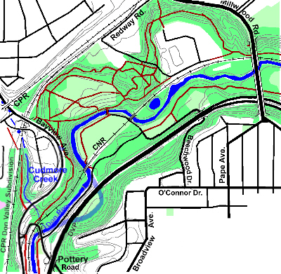
This stretch of the Don Valley between the Leaside Viaduct and Pottery Road, is well treed and includes a splendid fragment of surviving deciduous forest that is called Crother’s Woods. Thus the name of this reach. The only mapped tributary in this reach is Cudmore Creek, which enters the river just before Pottery Road. While not re-routed as much as further south, The Don’s route was changed in one place in mid 20th century to accommodate the Don Valley Parkway. The old course of the river is shown in light blue on the map below.
There are many bridges across the Don River and this stretch is no exception. To see a list with pictures of the bridges along this reach, go to Crother’s Bridges.
The woodlands along the Don Valley and its tributary ravines add much to the City. In the year 2000 The City of Toronto engaged the Toronto and Region Conservation Authority to study the natural heritage features of the newly amalgamated city. See the City of Toronto Natural Heritage Study. An overlay showing vegetation communities for the map can be seen by clicking as noted below.
While originally this area drained directly to the Don River, direct access is now blocked by streets, railroads and The Don Valley Parkway; so most storm water must pass through various culverts and small storm sewers to reach the river. To get an idea of how storm water is managed, see RiverSides’ Water in the City Walk. Sanitary sewage flows to the Ashbridge’s Sewage Treatment Plant. The North Toronto Sewage Treatment Plant in this area serves the former Town of North Toronto and the former Village of Forest Hill.
Click here to see the City of Toronto's Natural Heritage Study vegetation communities. Double click to remove.
Traversing This Area
There are many trails in this area, from the hard surfaced Lower Don Recreational Trail to crude earth trails made by mountain bikes. There are also a number of access points including: the Lower Don Trail coming down from the Forks, Beachwood Drive, Pottery Road, Bayview Avenue near the CPR underpass, Redway Road and the access road to NTSTP, a stairs at Millwood Road And Redway Road leads to the NTSTP and the access road from NTSTP to a Hydro Pylon east of Leaside Viaduct that connects with mountain bike trails from the Forks. There is also a foot bridge across the Don at the Snow Dump, joining the two sides and providing greater flexibility to those wishing to explore.
To follow the south and east side of the Don River, take the Lower Don Trail coming down from the Forks. Just before reaching Beechwood Drive, there is an open area which is the site of the former Domtar - Don Valley Paper Mill, a pioneering mill in Canada’s paper industry. Here one can continue on down the Lower Don Trail past the Beechwood Wetland or take a route closer to the river by following Beechwood Drive to the foot bridge across the river. Here pick up the foot path that circles around the Snow Dump Site and under the CNR bridge to rejoin the Lower Don Trail. Before going under the bridge look across the river to see the shale bank; this is the only place in the Don Watershed that Toronto’s Ordovician bedrock can be seen above the surface naturally.
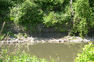
Toronto’s bedrock shows above ground at bend in Don River.
After rejoining the main trail, and continuing on south, we go along a bit of the Don that was re-routed to accommodate the DVP and pass one of the weirs built to slow the river’s flow and which has been recently modified to expedite fish movement. Continue on down. Just before Pottery Road, look across the river to see where Cudmore Creek enters. At Pottery Road one can leave the valley or continue on down though the Ravines Reach.
To follow the north an east side of the Don, is not quite as simple. First it is recommended that you NOT use the trails between the CNR and the river, because this would entail crossing the railline at other than a legal crossing. This is both dangerous and illegal. See Railway Lines and Safety. The straight forward route is to pick up the access road where it passes under the Leaside Viaduct and follow it till it turns north-west towards Loblaws, passing the North Toronto Sewage Treatment Plant. A detour to visit this historic institution could prove informative. At the bend find a trail that runs south-west along a hydro line. You will pass the core Crother’s Woods. Here you might wish to detour onto one of the bike trails to explore and enjoy this fine woodland. You will come out into a more open area which is the top of a sanitary landfill in the Sun Valley Brickworks quarry. Take any trail across this area to find a trail running south between Bayview Avenue and the Don River. Follow it to Pottery Road where you can leave the valley or continue on down though the Ravines Reach. Another route that could interest you is to follow the bike trails through the woodland behind the NTSTP and the Sun Valley Brickworks and the trail mentioned above between the Don and Bayview to end at Pottery Road. You might also combine routes by crossing the foot bridge at the Snow Dump or many more variations.
To visit Cudmore Creek, cross Bayview Avenue at Pottery Road with the lights and follow Bayview north on the paved shoulder to the Cudmore Creek Ravine. A lost bit of old Pottery Road goes up this valley.