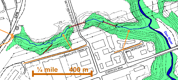
1 km of Walmsley Brook, from the CPR tracks to the West Don River
The Power Lines Reach, which takes us from the CPR tracks to the West Don River, is divided into two ravines by Beth Nealson Dr. Neither is easily accessible, but both are natural or near natural areas and as such, well worth visiting. The creek flows on the top of the ground though these ravines, with little or no constraints, so this is a good place to study stream dynamics. Gravel bars, old channels, and bank and slope erosion can be observed. It was located in the former Borough of East York.
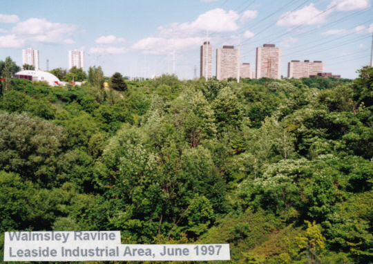
While it may be tempting to follow the CPR tracks down from Wickstead to the microwave tower, one should be warned that following railway tracks is both dangerous and illegal (See Railway Safety). The better route to the microwave tower, which is only a bit north of the point where Walmsley Brook crossed the tracks, is by the road that lead from the end of Thorncliffe Park Drive. There one can fight one’s way down into the west ravine, but it is recommended that the ravine be skirted on the south to a bulldozed trail across from the Coca Cola Plant on Thorncliffe Park Drive, which leads down into the valley. (Picture) From the bottom of this trail, one can explore up and down the valley. The few trees along this street are mostly Norway Maple, but there is a clump of Red Oak just west of the truck depot. Note the wet meadow bordered by Sumac on the table land above the ravine. There are several species of sedge and other small wet meadow species to be found here.
The tree growth in the ravine has been cut back to prevent it interfering with the power lines overhead, so it is mostly young growth. Part is a jungle of Manitoba Maple, Sumac, White Birch and Balsam Poplar. Goldenrod, Honeysuckle, Virginia Creeper and Sarsaparilla are present on the table land. Some White Ash and Black Cherry were noted. Sugar Maple and Elm with Alternate-leafed Dogwood and Grape are present on the slopes. One slope section is quite wet and supports a stand of Cattails from top to bottom. Other parts of the slope are more open with Sumac copses. The bottom is relatively flat and partly open with Raspberry and Red Osier Dogwood. Manitoba Maple, Crack Willow and White Birch are abundant with Red Oak, Basswood, Elms and Poplars. Dog Strangling Vine, Goldenrod, Sumac and Sandbar Willow were observed. Green Frogs are present in this ravine.
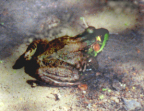
Green Frog in Walmsley Ravine, June 1997
The east and west ravines are divided by Beth Nealson Drive. This street is named in honour of Beth Nealson, the last Mayor of the Town of Leaside from 1963 to the end of 1966.
The first part of the east ravine is difficult to traverse. It is a “V” shaped valley with many Manitoba Maples that have fallen nearly parallel to the ground and spreading clumps of Crack Willow. There are many chunks of broken concrete in the valley bottom as well as granitic erratics. One can walk down a moderately steep slope from Beth Nealson and fight one’s way along the creek through the jungle to where it enters a pipe for a short distance. The slopes near Beth Nealson are fairly open with Raspberry, Equisitum, Goldenrod, some Aspen and the odd Sumac, Willow, Manitoba Maple and Yew. The valley bottom is a jungle of Manitoba Maple, Crack Willow, with a few Sugar Maple. Japanese Knot Weed and Liverwort were noted.
From the piped section one can take a path used by trail bikes down the valley to where Walmsley Brook meets The West Don River and further along the river under the Overlea Bridge to the Forks of The Don and a road leading up to the Thorncliffe Park area (about a Kilometre). In this lower valley, the woodland improves into a Sugar Maple bush with associated species such as Red Oak, Hemlock, Elm, Poplar and Grape. There is some flat bottom land. Posts along an oil pipeline in the lower valley; warn us not to dig without first checking with the company. Across The Don we can see Ernest Thompson Seton Park.
Another path into the east ravine starts at the end of the road through the allotment gardens on the south side of the ravine off Beth Nealson Drive. Deer have been seen near here in the early morning. The top of this path is not well marked and is very steep, but does lead down to the piped section from where one can take the trail bike path down the valley.
In the winter, when the leaves are off, one can look down from the end of William Morgan Drive and see where Walmsley Brook enters The West Don River.
Comment on Power line safety.