2.3 km of Walmsley Brook, Bayview and Eglinton to the CPR and one small tributary, Northlea Stream, 800m
This reach which starts near the edge of the North Toronto highlands at Bayview and Eglinton takes us across the level terrain of the Lake Iroquois terrace to the CPR main line tracks. This is in the former Town of Leaside. Walking the western half, we travel along tree shaded mostly residential streets. The eastern half takes us across industrial lands. The Leaside Airfield, notable as the terminus of the first official airmail flight in Canada, was located here.
Click here to see sewers. Double click to remove.
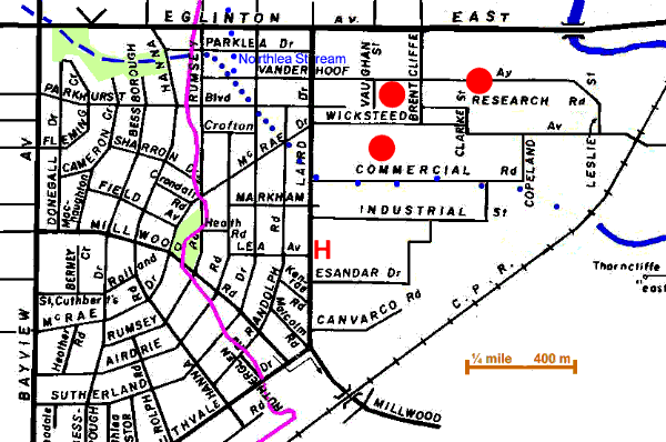
Leave Bayview & Eglinton follow Howard Talbot Park to Parklea Dr. & Hanna Rd. and Parklea Dr. to Rumsey Road. Twelve thousand years ago, Walmsley Brook flowed between rolling hills to enter Lake Iroquois’s Don Bay near Parklea Drive and Rumsey Road. From Rumsey Road to Vanderhoof Ave. note the change in topography. Looking up the streets to west we see rolling hills; to the east we observe a lacustrine plain that originated in Lake Iroquois’s Don Bay. Walmsley Brook’s entrance into the lake was gentle and has not been modified by a later deep ravine as have several of the other creeks.
At Vanderhoof Ave. we start across the lacustrine plain. The relief is nearly flat and actual course of stream is difficult to follow. Follow Vanderhoof Ave. to Sutherland; south to Parkhurst Blvd; along to Randolph; south to McCrae Dr. along McCrae to Laird Dr. and south to Commercial Road. There is a fair tree cover in this part of Leaside dominated by Norway Maple with Colorado Spruce, White Birch, White Cedar and the odd Crab Apple and White Pine. Past Parkhurst the tree cover becomes light and along Commercial it is absent. The small tributary, Northlea Stream, joined Walmsley Brook where it crossed Vanderhoof Ave. Northlea Stream started near Broadway and Hanna, flowed south east to cross the south-west corner of Northlea Public School grounds, where it took a more southerly direction to its junction with Walmsley Brook.
The Lea Family farm occupied a good part of what became the Town of Leaside. Their home stood about two blocks south of here near the intersection of Laird Dr. and Lea Avenue
Go east along Commercial Road. The stream followed a route close to this street. Canada Wire and Cable, which was the first industry establish in the former Town of Leaside, was located between Commercial and Wicksteed. Nothing remains from this enterprise. The Leaside Airfield, which was also located in this area, was used in W.W.I as a training base for the Royal Flying Corps. It is also notable as the terminus of the first official airmail flight in Canada. 1918/6/24. For the story of this flight see Fifty Tales of Toronto by Donald Jones U of T Press. A notable W.W.II venture, which located in this area, was Research Enterprises Ltd.
At the end of Commercial, Walmsley Brook flowed SE, crossing CPR tracks 100 m south of the microwave tower. The stretch between Commercial and the CPR is usually not accessible and is not really interesting. Go north on Copeland and east on Wickstead Ave. and across the tracks. Follow Wickstead Ave. east and Beth Nealson Dr. south to the next reach, The Power Lines Reach.