In this reach, Castle Frank Brook was known at one time as Brewery
Creek or Severn Creek, after John Severn, an Aldermen of the Village of Yorkville, who opened a brewery along this stream in 1835. The areas beside this reach are diverse and include the trendy Yorkville, stable Annex, old but still fashionable South Rosedale, and stylish shops along Bloor Street.
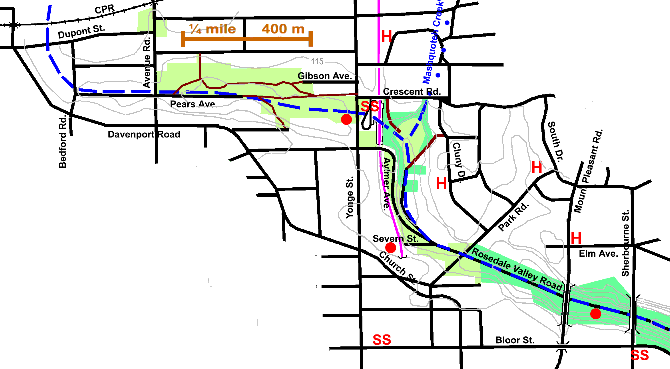
2.3 km, tracing the path of Castle Frank Brook through the former Village of Yorkville; from the CPR tracks to the Sherbourne Street bridge.
Click here to see sewers. Double click to remove.
While the storm water runoff still flows down the valley, it does this in a very large pipe rather than an open stream. Sanitary sewerage flows via the Core Interceptor Sewer to The Main Sewage Treatment Plant at Ashbridge’s Bay, except in the case of a Combined Sewer Overflow episode when it is diverted into the storm sewer and enters the Don at the foot of this valley.
Take Dupont Street to Bedford Road and south to Pears Avenue which runs close to the former stream. Follow Pears across Avenue Road and enter Ramsden Park, which is established on the site of the former Pear’s or Yorkville Brickyard. This is a more manicured park than Nordheimer Ravine, which has been kept natural at least in part. There are some native and some introduced trees to be seen in Ramsden Park including: a clump or coppice of Basswood; Red and Austrian Pines; Ginkgo, Cottonwoods and Catalpas (south of tennis courts) and Tulip Trees & Kentucky Coffee Trees (east of courts) There is a Plain Tree on Gibson Street. Main sanitary sewers from Deer Park, Davenport Road and Poplars Plains Road meet at corner of Crescent Rd. & Yonge. This combined sewer continues down Rosedale Valley to near Sherbourne Street, where it meets an overflow sewer to the Don and an interceptor sewer down Parliament to the three metre Mid-Toronto Interceptor Sewer.
Cross Yonge Street at Crescent Road to Rosedale Subway Station and walk east along Crescent Road to take a path down into the ravine on the east side of the subway right-of-way. Trees along this path include: Black Locust, Silver, Sugar and Norway Maples, and, down the slope, Ash, Manitoba Maple, Horse Chestnut, Buckthorn and a fine old Red Oak.
We enter Severn Creek Park. John Severn, one of the first Aldermen of the Village of Yorkville, opened a brewery here in 1835. As a result, Castle Frank Brook became known as Brewery Creek or Severn Creek. Apparently in his search for good water for his brewery, Severn went to the length of building a four mile long pipeline along the west side of Yonge Street to York Mills where there was an outstanding spring.
The Rosedale Subway Station is located over the former Castle Frank Brook ravine, which has received a great deal of fill here at the Yonge Street crossing. In early days, the Yonge Street crossing of this ravine was extremely difficult. The bluish clay on the summit of both hills gave it the name Blue Hill and so the stream was also known as Blue Hill Creek. Wagon traffic had to struggle up and down two difficult tracks cut into the steep hillsides, which in the Fall and Spring were almost impassable. (See Construction of Yonge Street through Yorkville).
Next to the subway station there is some naturalization and planting: Red & Burr Oaks, White Pine, Sugar & Silver Maples, Hemlock, Sumac and shrubs. As well as trees mentioned earlier there are White and Red Oaks on the ravine walls, some large Ash and Dotted Hawthorn. One Shagbark Hickory was seen. Note the end of Mashquoteh Creek’s ravine in the north east corner of this park. Trees in the grassed area of the park include: Honey Locust, at least two varieties of Norway Maple and Crab Apple Apples. Pass the path to Cluny Drive and commence walking down Rosedale Valley Drive to its junction with Severn Street and Aylmer Ave. Trees in this stretch: Crack Willow, Cottonwood, Manitoba & Norway Maples, Elm, Horse Chestnut, Austrian Pine, Sumac and Crab Apples.
The area south of Aylmer Avenue to Park Road is now called Lawren Harris Park after the painter, a member of the Group of Seven. Norway & Silver Maples, Honey Locust and Colorado Spruce. Hazeldean Park is made up of the three other parcels at the corner of Park Road & Rosedale Valley Road. This area was once owed by Chief Justice Draper, who used it for his rural cottage which he called Hazeldean. In this small park we also see: Ailanthus, White Oak, European White Birch and Linden and, south of Park Road, Ginkgo, Black Locust, White Pine and Silver Maple. These parks are largely mown grass, but some of the slopes have been naturalized.
Rosedale Villa, the house that gave its name to this area of the city, stood at the top of this stretch ravine on the east side. If one walks up Park road to # 124 one can see Caverhill, also known as the Geary House, which is one of Toronto’s oldest residences still in use as a family home.
Past Hazeldean Park, the ravine is fairly narrow and the road occupies most of its bottom, but there is a good bicycle path on the south west side that can be followed to Bayview. The sides of the ravine are wooded with a mixed quality forest dominated by Norway Maple, a very invasive exotic, Manitoba Maple, Ash, Ailanthus, Horse Chestnut, Elms and Crack Willow. One can see an occasional old White or Red Oak, White Pine or Hard Maple on the upper slopes and a few patches of intermediate aged Oaks, Basswood, Aspen, and Cottonwood along the road. Grapevines, Poison Ivy, and Japanese Knot Weed should be noted. At entrance to parking garage on the SW note glacial boulders. Just past Mount Pleasant Bridge on the SW observe the growth of pioneer species in open area, Manitoba Maple and Japanese Knot Weed. The site of Bloor’s Brewery was between the Mount Pleasant Bridge and the Sherbourne Street Bridge. At the latter we pass into the Rosedale Valley Reach having left old Yorkville.