2.1 km of Cudmore Creek from Eglinton and Mount Pleasant Road to Bayview Ave. north of Moore Ave.
Cudmore Creek in this reach ran through an area that is now residential except in the north along Eglinton and at the south where its former course in buried under Mount Pleasant Cemetery. For several blocks along Forman Avenue, two trunk sewers (storm and sanitary) follow closely the course of the former creek. The storm trunk sewer serves the Mount Pleasant and Eglinton area. The flow from this sewer is diverted under Mount Pleasant Cemetery to Mud Creek. The Sanitary Trunk Sewer serves much of North Toronto and feeds the Main Trunk Sewer along Balliol Street heading to the NTSTP. The Cudmore Creek valley through Mount Pleasant Cemetery was completely obliterated in the early 50s by fill from the construction of the Yonge Street Subway.
Click here to see sewers. Double click to remove.
To see trunk sewers click here. to remove double click.
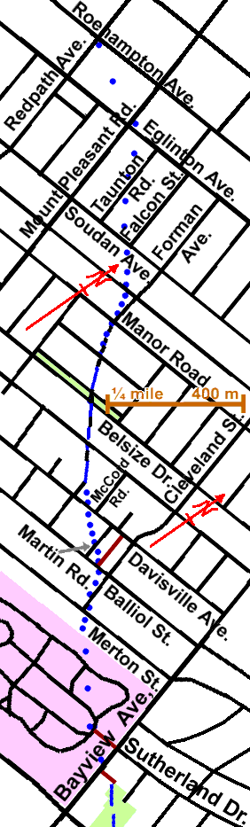
The evidence for this creek in the block from Roehampton Ave. and Redpath Ave. to Eglinton and Mount Pleasant is very indistinct. It is suggested that a walk be started at Eglinton and Mount Pleasant. Walk east to Falcon St. and south to Soudan Ave., noting as one passes Taunton Rd. that the storm trunk sewer serving this area starts here and we will meet it again at Falcon and Soudan. Walking down Falcon St. we begin following the Trunk Sanitary Sewer that serves most of North Toronto east of Yonge or north of Lawrence. At Soudan Ave. and Falcon, we meet the storm trunk mentioned earlier. We can also note a dip in the streets marking the former creek.
We follow both sewers along Soudan and south along Forman Ave. From Manor Road to Davisville Avenue Forman Ave and the two trunk sewers follow quite closely the route of the former creek, which is in an obvious valley. At Belsize Drive we cross a small park, well treed, but mostly Norway Maples with some Lindens Elms and Ash. A little north of Davisville Avenue, Forman and the sanitary trunk sewer turn south. The sewer meets the Balliol Combined Trunk Sewer along Balliol Street on it way to the NTSTP in the Don Valley south of Laird Drive.
At Davisville Avenue, go east to a lane east of Martin Rd. The storm trunk follows Davisville from McCord Rd. to this lane. We follow this sewer down this lane to Balliol Street. The storm trunk sewer continues south, joining another storm sewer at Merton Street serving Bayview, into Mount Pleasant Cemetery. The storm sewer flows south through Mount Pleasant Cemetery to empty into Mud Creek. Jog east to Cleveland Street along Balliol Street and south to Merton Street. The creek crossed Merton Just east of Cleveland Street and flowed south east across Mount Pleasant Cemetery where it is buried under many feet of fill. Follow Merton east to Bayview Avenue then south past Sutherland Dr. and the pedestrian gate into Mount Pleasant Cemetery, to follow Cudmore Creek along The Bayview Reach.